Image of the week gallery
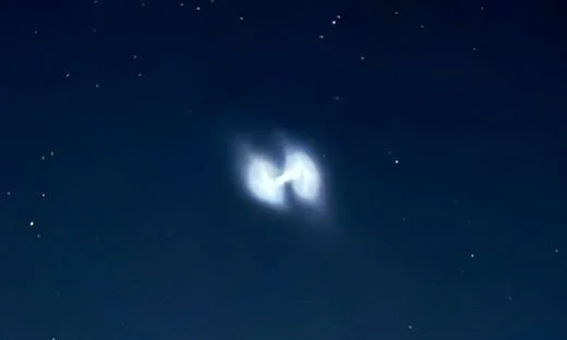
Spiraling Rocket Exhaust
Many saw this on Tuesday night, August 12th, in the eastern US as they were looking for Perseid meteors…according to spaceweather.com,
“this is probably a fuel dump linked to a Vulcan Centaur rocket launched from Cape Canaveral by the United Launch Alliance (ULA). Carrying two satellites on behalf of the U.S. military, the rocket lifted off at 8:56 p.m. EDT on Aug. 12th (0056 GMT on Aug. 13th). When multiple satellites are deployed from a single rocket, the rocket sometimes spins to help the payloads go in different directions. That could account for the spiral shape of the exhaust.”

The Perfect Tornado
Severe weather threats have continued into the late spring across much of the nation as we have had numerous clashes between colder-than-normal air masses and warm, humid air. On Monday, June 16th, this clash in the atmosphere resulted in numerous damaging wind and hail reports across the state of Nebraska and there was at least one tornado reported. This photograph was taken in Wellfleet which is located in the southwestern part of Nebraska. The threat for severe weather will continue today, Tuesday, June 17th, across the nation’s mid-section including again the state of Nebraska and Kansas and Oklahoma as well.
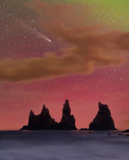
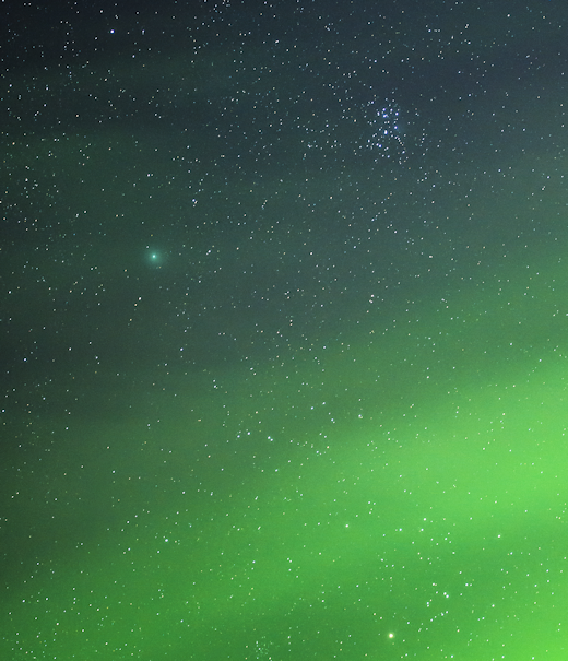
Northern lights and a comet
Comet Tsuchinshan-ATLAS has faded since its urban-bright display in mid-October, but it is still a great target for night sky photographers. Wioleta Gorecka photographed the comet on Oct. 26th, 2024 from Vik, Iceland at the same time auroras were coloring the nighttime sky in the Arctic Circle with pinks and red (courtesy spaceweather.com).
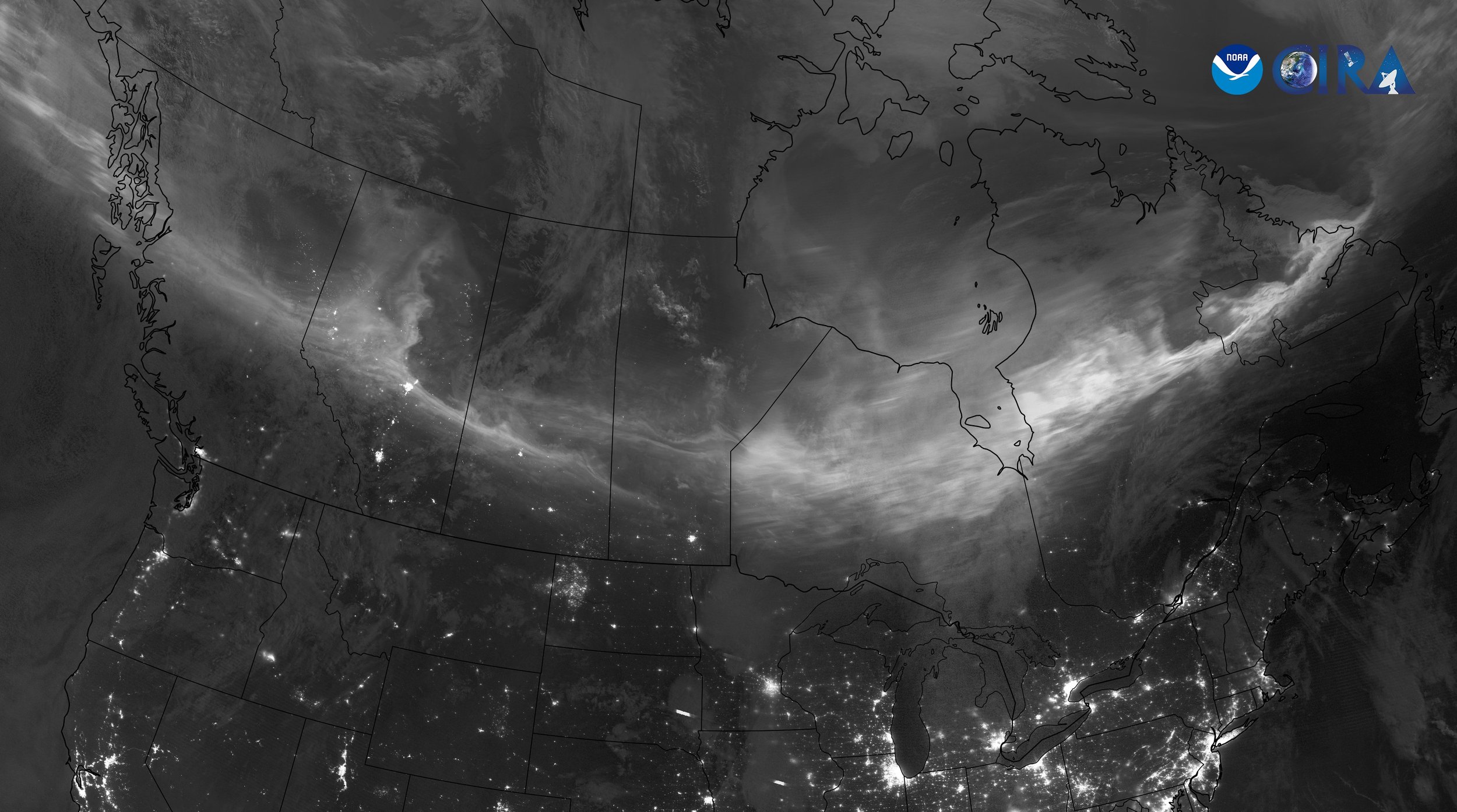
Northern Lights Captured on Satellite
A geomagnetic storm reached Earth on Tuesday night, July 30th, leading to the appearance of the northern lights over Canada. JPSS satellites utilized the "day/night" band to capture the aurora borealis seen in this composite image. Credit: NOAA/CIRA
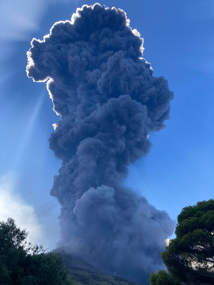
Stromboli Volcano (Sicily, Italy)
A very strong explosion occurred from the Stromboli volcano in Sicily on Thursday, July 11th and a massive ash plume rose from the summit area and drifted over the southeastern part of the island. Stromboli is one of the most active volcanoes in the world – renowned for its regular, but normally minor, eruptions that send lava oozing from vents inside its crater. It has been active for thousands of years. The minor eruptions which are often visible from the island and surrounding sea have given rise to its nickname of the “Lighthouse of the Mediterranean.” Credit Image: Francesca Utano, volcanodiscovery.com
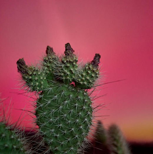
Auroras in strange places
A very large sunspot region unleashed a series of coronal mass ejections (CMEs) that impacted the Earth's atmosphere on Friday night and Saturday (May 10th/11th, 2024). In fact, this was one of the strongest solar storms in many years and it resulted in northern lights being visible in some unusual places such as Mexico and Puerto Rico.
Kyle Nulla Cognomen sends this picture from Las Vegas, Nevada. "What a gorgeous view of the desert sky illuminated by aurora," he says. "I could see the reds and greens with my naked eye!" {Courtesy spaceweather.com}
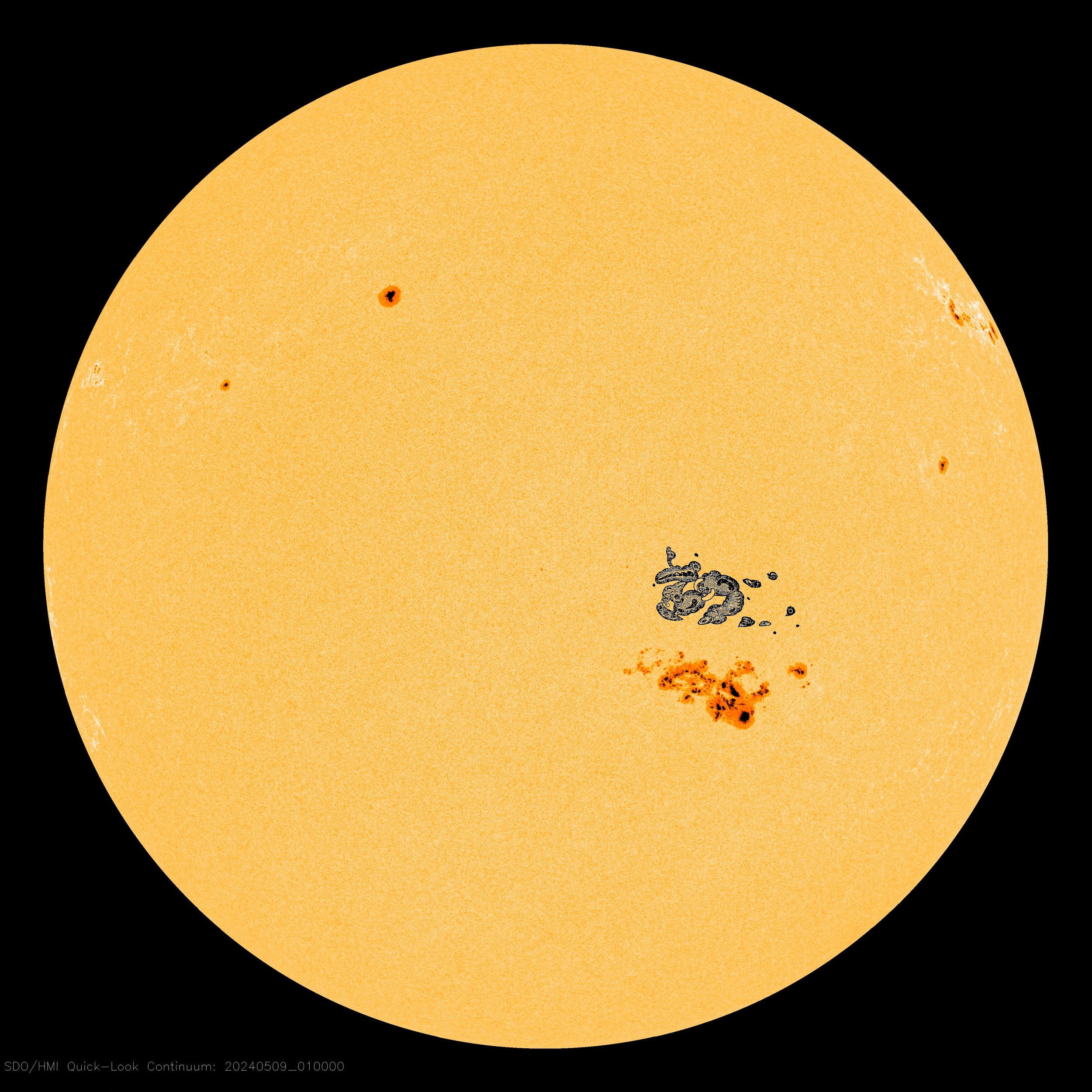
Large sunspot region on May 8th, 2024 that rivals "The Carrington Event"
Sunspot AR3664 has grown so large, it now rivals the great Carrington sunspot of 1859. To illustrate their similarity, spaceweather.com has added Carrington's famous sketch (to scale) to a NASA photo of today's sun. Sprawling almost 200,000 km from end to end, AR3664 is 15 times wider than Earth.
On September 1st, 1859, a ferocious solar storm took place that impacted much of the planet. This ferocious solar storm is now known as the “Carrington Event”, named after the British astronomer, Richard Carrington, who witnessed the largest solar flare from his own private observatory which caused a major coronal mass ejection (CME) to travel directly toward Earth.

Volcanic eruption in Indonesia (April 17th, 2024)
Hundreds of people in Indonesia had to be evacuated from their homes in the North Sulawesi province as the Ruang volcano continues its days-long eruption. The volcano has been seen filling the sky with red ash as the country's volcano monitoring agency reports hundreds of deep volcanic earthquakes. Indonesia's National Agency for Disaster Countermeasure, known as BNPB, said in a news release on Wednesday that volcanic activity has increased, prompting officials to raise the alert level to three – the second-highest warning level in their monitoring system. Video taken by the agency showing massive red bursts filling the sky as lightning flashes within it. (Photo courtesy Mark Margavage, X; news info courtesy CBS)
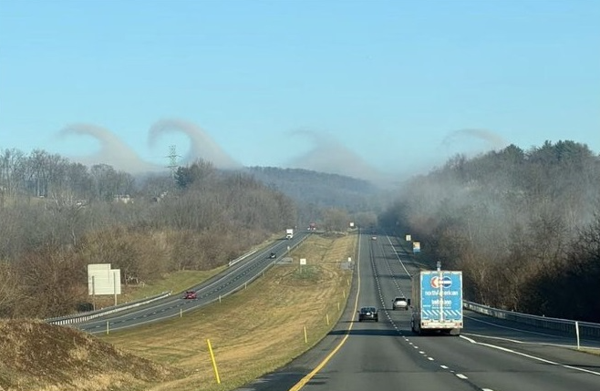
Kelvin-Helmholtz clouds
These wave clouds were created by an atmospheric phenomenon known as Kelvin-Helmholtz instability and were seen over the Catoctin Mountains in northern Maryland on Sunday, March 3rd, 2024. (Photo courtesy Joe Bastardi, Twitter)
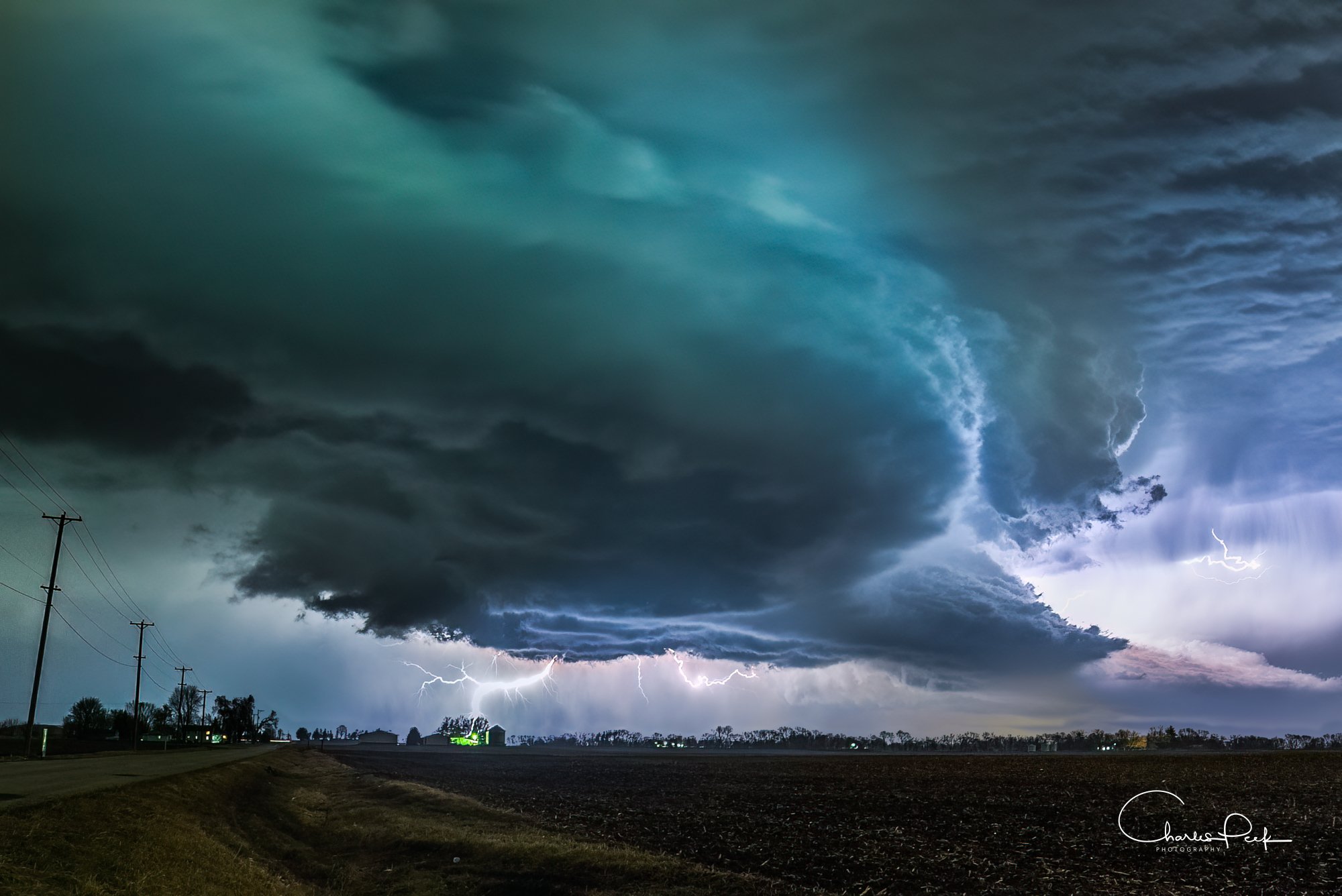
Supercell
A photograph of a “tornado warned” supercell in Yorkville, Illinois on Tuesday evening, February 27th, 2024. Severe weather broke out across northern Illinois just ahead of a powerful cold frontal system. Photo courtesy Charles Peek (Twitter)
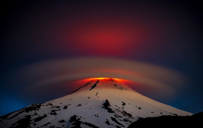
Perfect Lenticular Cloud
Villarrica is one of Chile's most active volcanoes; eruptions have been recorded since the conquest of Chile and the founding of the city of Villarrica in 1552. This image of a perfect lenticular cloud over the top of the volcano was taken during the middle of October (2023).
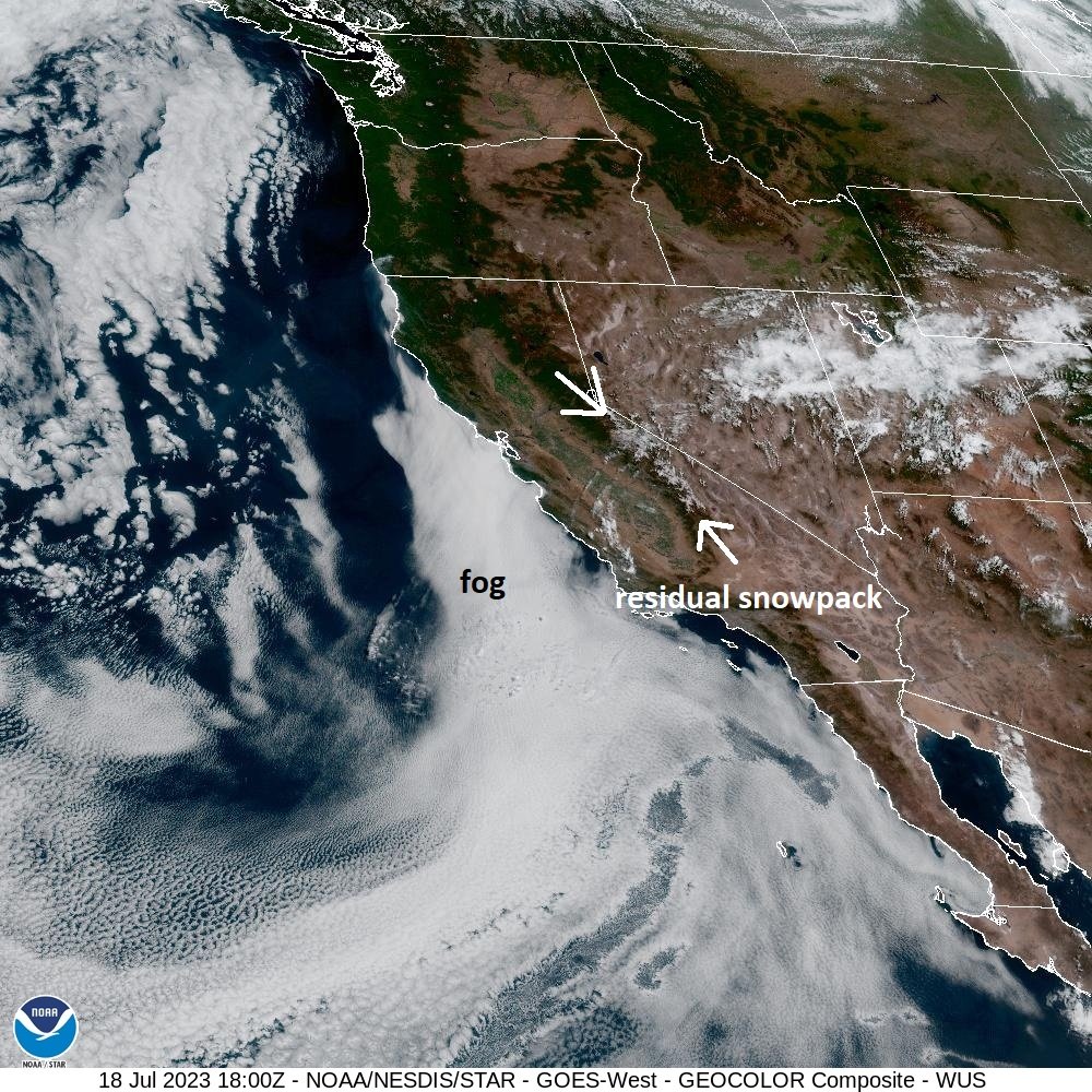
An interesting satellite image of California
A close-up satellite image of California on Tuesday, July 18th, 2023, reveals some interesting features. A fog bank can be seen just off the coast over the cool waters of the eastern Pacific. This fog bank was “retreating” at mid-day on Tuesday as daytime heating was having an impact on relative humidity levels. In addition, snowpack in the Sierra Nevada Mountains of eastern California is still in evidence as we head into the second half of July. This is despite the fact that hot weather has encompassed the Golden State in recent days. (Note -there are a few clouds over the snowpack region). This past winter season of 2022-2023 brought record snowfall amounts to the Sierra Nevada Mountains. Image courtesy NOAA/NESDIS/GOES-West (GEOCOLOR Composite)
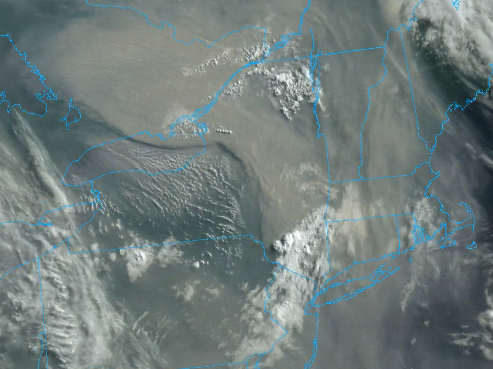
Smoke-filled skies Northeast US/Mid-Atlantic
Wildfires in Quebec, Canada are leading to smoke-filled skies in the Northeast US and Mid-Atlantic region. The overall wind flow in the northeastern states is NW-to-SE and this is carrying the smoke from southeastern Canada into the US. The smoky skies are leading to deep red/orange sunrises and sunsets as well as a “milky” appearance to the atmosphere. Image from June 6th, 2023
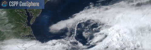
Rope Cloud
An interesting curved “rope cloud” feature (center of image) formed in a thunderstorm complex over the Gulf Stream region of the western Atlantic Ocean on Sunday, May 15th, 2023. Image courtesy University of Wisconsin/CIMSS
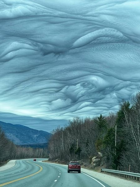
Undulatus Asperatus clouds
“Undulatus asperatus” clouds were seen over New Hampshire on Sunday, April 23rd ahead of an incoming storm system. These wavy clouds are usually below 7,000 feet and associated with a thick layer of turbulence. Asperitas is a cloud formation first popularized and proposed as a type of cloud in 2009 by Gavin Pretor-Pinney of the Cloud Appreciation Society. Added to the International Cloud Atlas as a supplementary feature in March 2017, it is the first cloud formation added since “cirrus intortus” in 1951. Photo courtesy WMUR; info courtesy Wikipedia
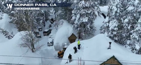
Sierra Nevada record breaking snowpack
This snapshot taken from a video features 3 people shoveling snow off the roof of a house after the latest storm generated several more feet of snow in the Donner Pass region of the Sierra Nevada Mountains. This winter season is very likely going to be the snowiest ever recorded in this higher-elevation region of eastern California. (Photo courtesy Twitter (Weather Nation), March 14th, 2023).
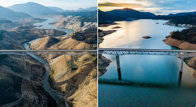
California drought
California has been getting pounded by storm-after-storm this winter season of 2022-2023 and it has virtually ended the drought in that part of the western US. These storms have filled California's Lake Oroville with more than 526 billion gallons of water—nearly half of its capacity—between 12/21 and 3/8, bringing it up 168 feet.
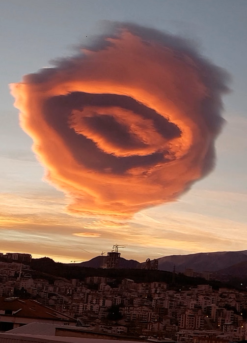
Lenticular Cloud
This photograph of an unusual lenticular cloud took place near Bursa, Turkey on January 20th, 2023. Bursa — where the cloud was seen — is about 50 miles south of Istanbul, across the Sea of Marmara. What made the cloud in Bursa especially aesthetically pleasing was the time of day it formed — shortly before sunrise. Its altitude, probably around 10,000 to 20,000 feet, allowed it to catch sunlight and be illuminated before the sun actually poked over the horizon and bathed the city in amber warmth.
Lenticular clouds (Altocumulus lenticularis, meaning “shaped like a lentil” in Latin) mostly develop among the crests and valleys of mountainous terrain. They are associated with waves in the atmosphere that form when moist air flow is forced up, over and partway down a mountaintop. Photo/information courtesy Washington Post (Capital Weather Gang); Hafize Aktas/Reuters.
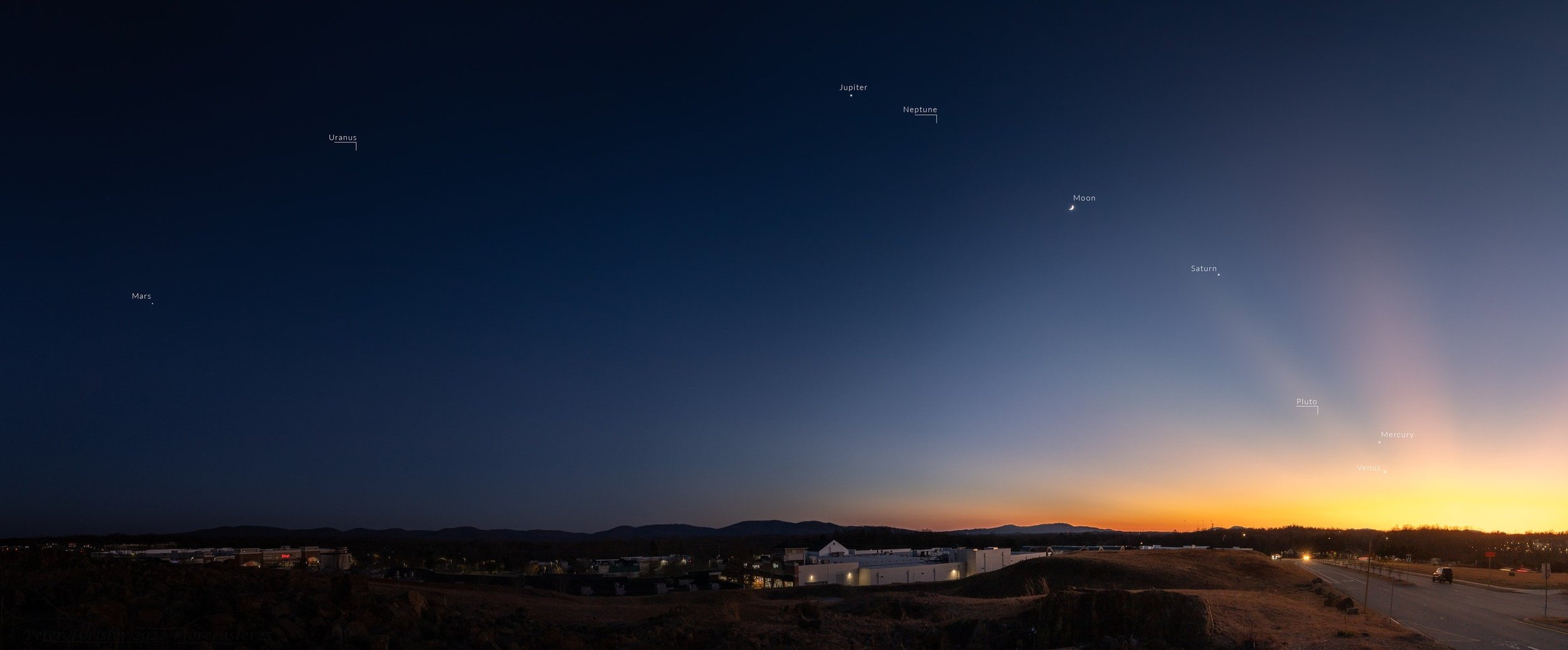
Sky show to end the year
Quite a sky show to end 2022 with numerous planets visible shortly after sunset. This photo was taken on December 27th in Charlottesville, Virginia and the planets that require telescope viewing are distinguished from the others which are visible with the naked eye. (Credit to Peter Forister (Twitter)).
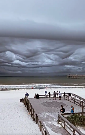
Asperitas Clouds
Asperitas clouds appeared over Fort Walton Beach, Florida on Monday, November 14th. These clouds are closely related to undulatus clouds. Although they appear dark and storm-like, they almost always dissipate without a storm ever forming. The ominous-looking clouds have been particularly common in the Plains states of the United States, often during the morning or midday hours following convective thunderstorm activity. (Info source Wikipedia)
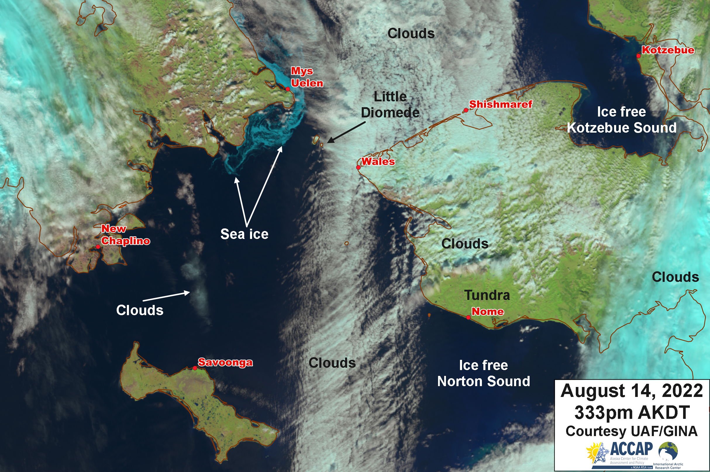
Sea Ice in the Bering Strait
In a sure sign that winter is not far away, sea ice was seen in satellite imagery on Sunday, August 14th as skies cleared over the western Bering Strait. False color Suomi NPP image shows ice extending ~55 miles (90km) SW of East Cape, entirely in Russian waters. (Courtesy Rick Thoman, Twitter)
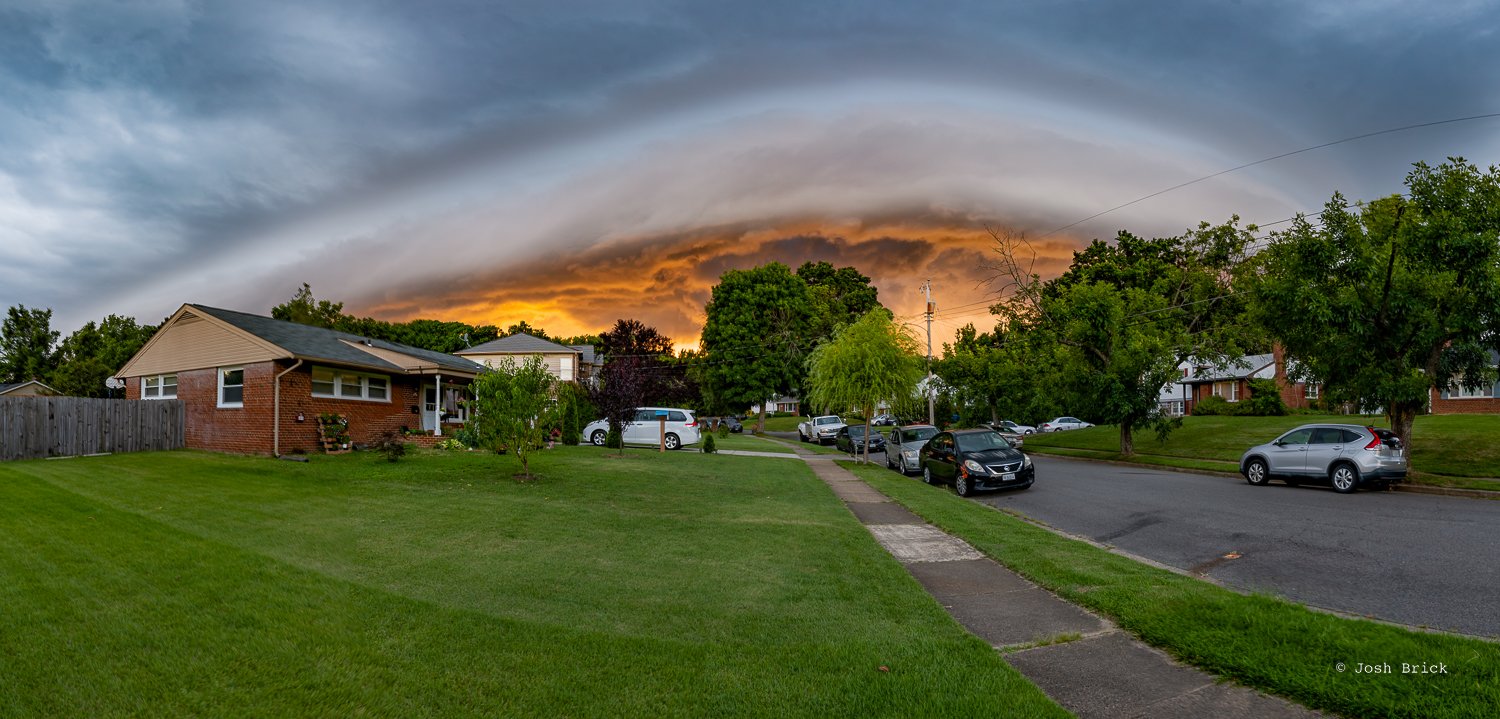
Shelf Cloud over northern Virginia
This photo of a shelf cloud was taken in Springfield, Virginia on Thursday, July 28th, 2022. A shelf cloud will usually be associated with a solid line of storms and can form at the leading edge. The wind will come first with rain following behind it. It may appear to rotate on a horizontal axis. Wall clouds will rotate on a vertical axis, sometimes strongly. If you see a shelf cloud coming your way, it probably means you are about to get hit by a strong thunderstorm. Photo courtesy Josh Brick Graphics/Capital Weather Gang
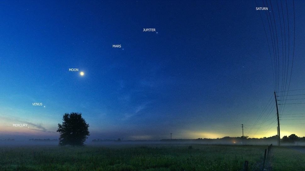
Alignment of 5 planets
The rare sight of five bright planets lining up with the moon wowed skywatchers around the world on Friday, June 24th and this kind of event won’t happen again until 2040. Throughout the month of June, Mercury, Venus, Mars, Jupiter and Saturn have lined up from left to right, in their orbital order from the sun, before dawn in the southeastern sky. Early Friday (June 24), the moon joined the planet parade in an awesome sight captured by astrophotographer Wright Dobbs, a meteorologist for the U.S. National Weather Service in Tallahassee, Florida. While the show did hit its peak on June 24th, there's still time available to see the planets in alignment, along with the moon. The moon moved through a planetary "meet and greet" in the predawn sky, passing Saturn on June 18, Jupiter on June 21 and Mars on June 22. The moon will continue its tour with a pass-by of Venus on June 26, and then end its tour with Mercury on June 27. (Courtesy space.com)
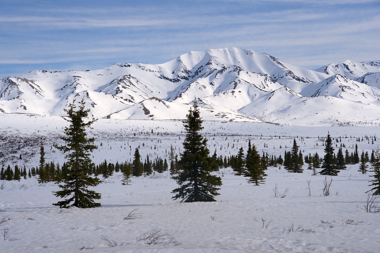
Snow cover remains in Denali National Park (Alaska)
Denali National Park, Alaska is still melting out from its snowiest winter season in more than 100 years of record keeping, and the unusually heavy, lingering snow is reportedly affecting park wildlife. Summer operations may have resumed on May 20, but there were still 33 inches of snow on the ground at Park headquarters — by far the most on record so late in the season. The Park Service headquarters received 176 inches of snow this winter season, besting the all-time record of 174 inches set in 1970-71. (Information source “electroverse.net” on Twitter)
This photograph was taken on May 22nd around 6 miles into the park somewhere between HQ and the Savage Alpine Trail campground.
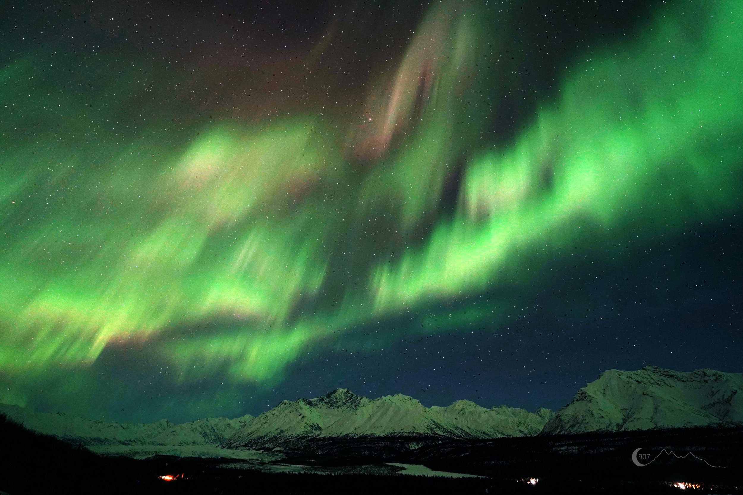
Northern Lights over Alaska
A coronal mass ejection (CME) reached the Earth’s magnetic field in the early morning hours of March 31st causing auroras in some not-so-typical places across the US and some of the more typical places like Alaska. This is a view looking to the southeast from Alaska’s Matanuska Glacier.
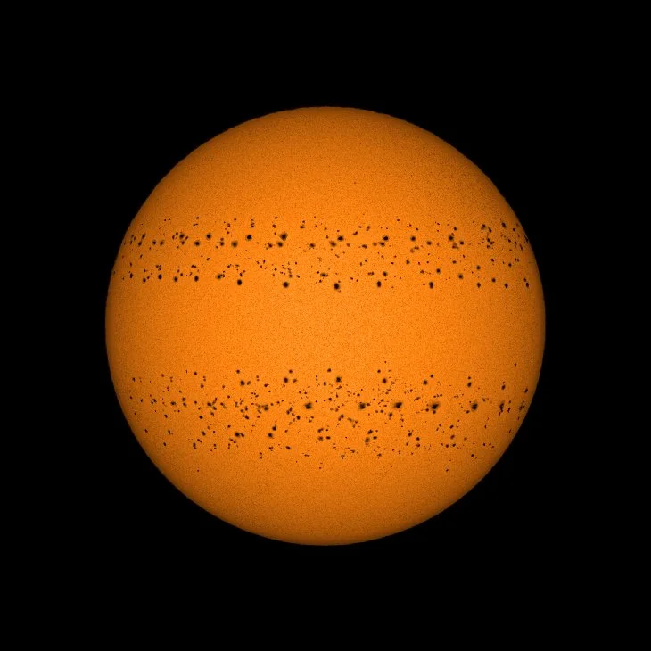
A Year of Sunspots...South vs. North
Courtesy spaceweather.com:
In late 2020, Indian amateur astronomer Soumyadeep Mukherjee decided to photograph the same sunspot for 7 days in a row. At the end of the week, he found he couldn't stop. "I kept going and photographed the sun for 365 days in a row," says Mukherjee. "This image is a blend of all the pictures I took," he says. "It shows every sunspot that crossed the solar disk from Dec. 25, 2020, to Dec. 31, 2021. Only 6 days are missing due to complete cloud cover."
The composite image reveals two things: First, all of the sunspots are concentrated in two bands--one north and one south of the sun's equator. Second, the south seems busier than the north. The southern band is wider and there are more sunspots.
Solar physicists have long known that the two hemispheres of the sun don't always operate in sync. The great Solar Cycle 19 of the 1960s, for instance, was mostly northern, an assymetry which persisted for more than 15 years. More recently, Solar Cycle 24 had a strong southern peak in the year 2014. Other cycles have been a seesaw mix of north and south with only razor-thin margins separating the two.
How will Solar Cycle 25 shape up? So far it is speaking to us with a southern accent.
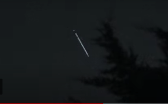
Train of Starlink satellites
This photograph of Starlink satellites operated by SpaceX was taken on Friday, February 25th from London, England by an amateur astronomer. The latest deployment of Starlink satellites was to replace those lost in early February due to impact from a geomagnetic storm. Photograph courtesy spaceweather.com
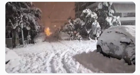
Blizzard in Greece
Athens, Greece experienced a major snowstorm on January 24th, 2022 that produced more than a foot and a half of snow in some spots as well as thunder and lightning. This was the heaviest snowfall in parts of Greece since 1968. Thousands of motorists were stranded in the blizzard which also hit parts of Turkey where as much as 31 inches of snow fell.
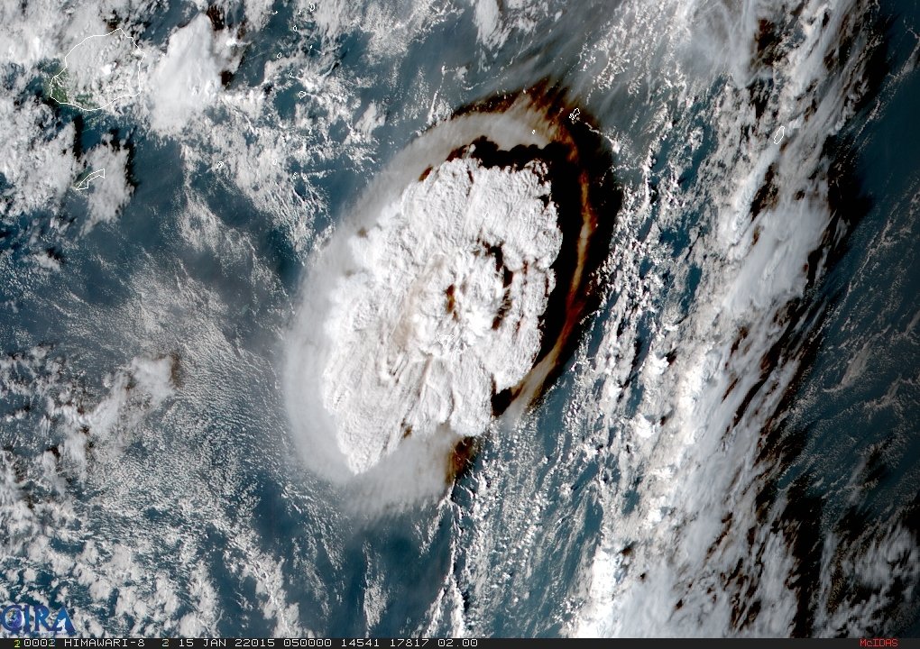
Tonga volcanic eruption
An undersea volcano erupted on Jan. 15th, 2022 near the Pacific island of Tonga, sending large tsunami waves crashing on shore and people rushing to higher ground. Japan's Himawari-8 weather satellite recorded this dramatic image. An atmospheric shock wave send a pressure surge around the world with spikes seen on barographs at around 1200 UTC.
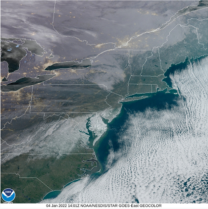
DC-to-Delmarva-to-NJ snow cover
Accumulating snow fell on Monday, January 3rd in the Mid-Atlantic region with a concentration in the zone from DC-to-the-Delmarva Peninsula-to-southern New Jersey. In this area, 6-12 inches of accumulation was commonplace. Dry air to the north of the storm track helped to produce a sharp cutoff in the snowfall with little to no snow in Philly and NYC and points to the north and west. Image courtesy NOAA/NESDIS/Geocolor
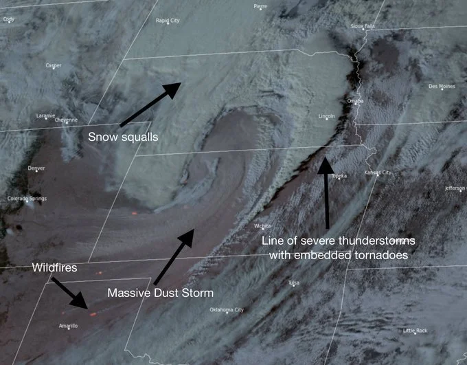
Powerful storm in the nation's mid-section
A powerful storm is causing a wide range of problems on Wednesday, December 15th in the nation’s mid-section from extreme wind gusts of 100+ mph, severe weather, accumulating snow, and even dust storms.
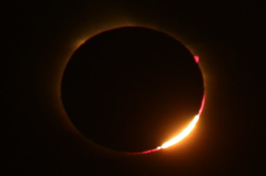
Antarctica Solar Eclipse 2021
The only total solar eclipse of 2021 took place under especially isolated circumstances today, sweeping over sparsely populated Antarctica and surrounding areas to create a spectacular sight visible to only a few dedicated eclipse chasers in its path. The partial phase of the solar eclipse began Saturday (Dec. 4) at 2 a.m. EST (0700 GMT), and included less than two minutes of totality at 2:44 a.m. EST (0744 GMT), before ending at 3:06 a.m. (0806 GMT). [Image courtesy Spaceweather.com]
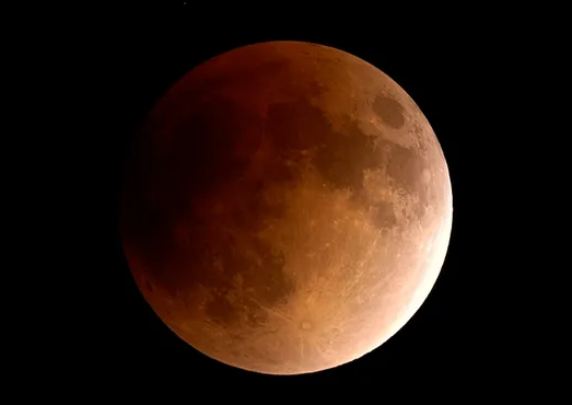
Lunar Eclipse
There will be a partial lunar eclipse during the wee hours of the morning on Friday, November 19th, 2021 visible in most continents including North America. This “partial” eclipse will actually be very close to “total” as nearly 97% of the moon’s surface will be shrouded in the Earth’s shadow at the peak. The eclipse will last about three and a half hours – the longest such eclipse in nearly 600 hours. What makes this eclipse so long? The Moon is near apogee, the farthest point in its orbit around Earth. Because the Moon moves slowly at apogee, it takes longer to cross Earth's shadow. According to Sky & Telescope, this will be the longest partial lunar eclipse since Feb. 18, 1440 — and we won't get a longer one until Feb. 8, 2669.
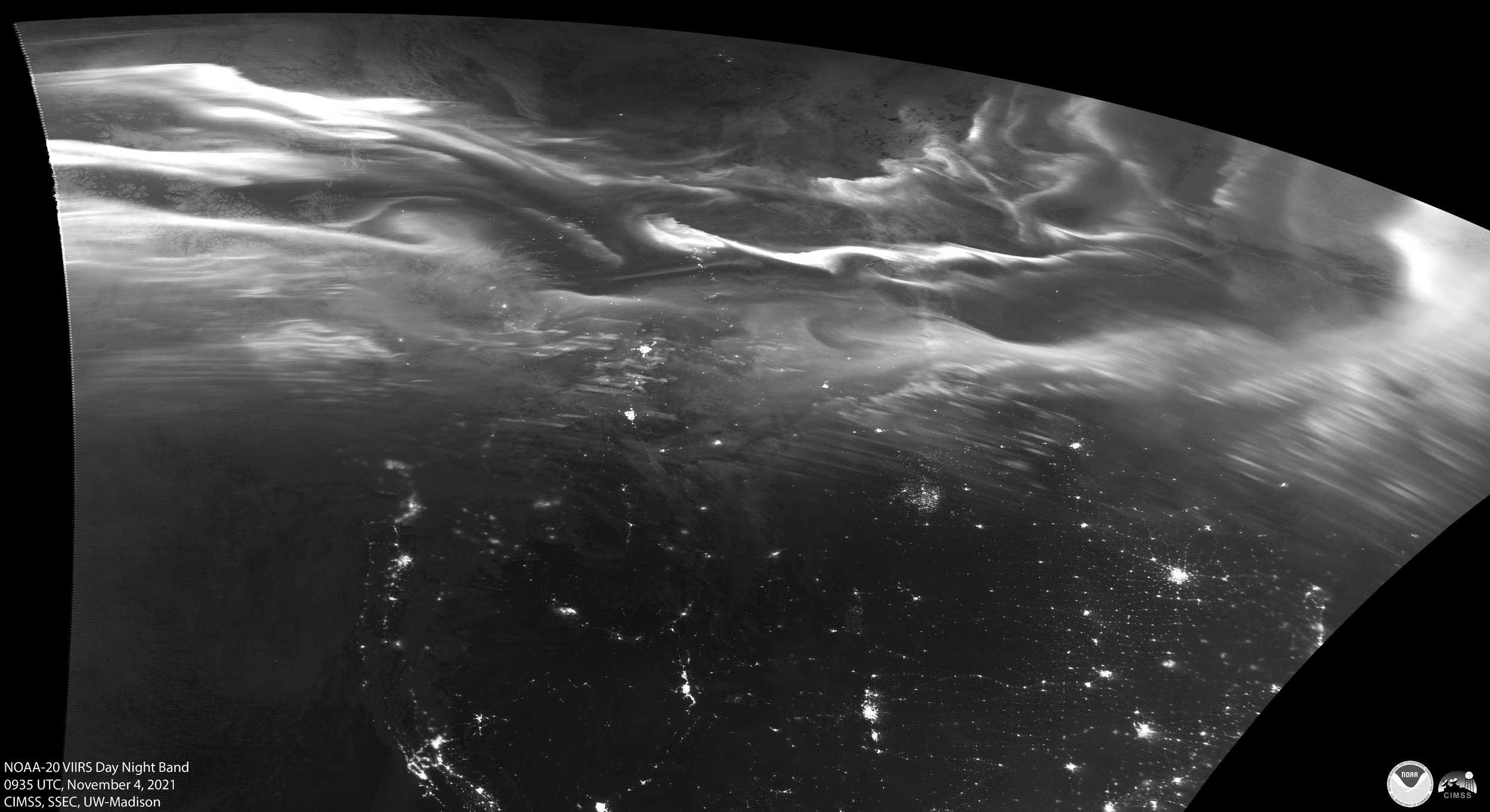
Northern Lights from Space
As solar cycle 25 gets farther along, the number of sunspots is climbing and the northern lights are becoming more frequent. Satellite image shows the northern lights on November 4th, 2021 over North America. Imagery from the NOAA-20 satellite and courtesy of UW/CIMSS.
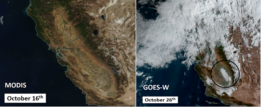
Sierra Nevada snow
“Before” and “After” satellite images reveal the dramatic differences with respect to the California landscape between October 16 and 26th, 2021. A pile of snow can now be seen in the higher elevation locations of the Sierra Nevada Mountains of eastern California following the first “atmospheric river” type of Pacific Ocean storm for the west coast this season. (Images courtesy NASA/MODIS (left), NOAA/GOES (right)
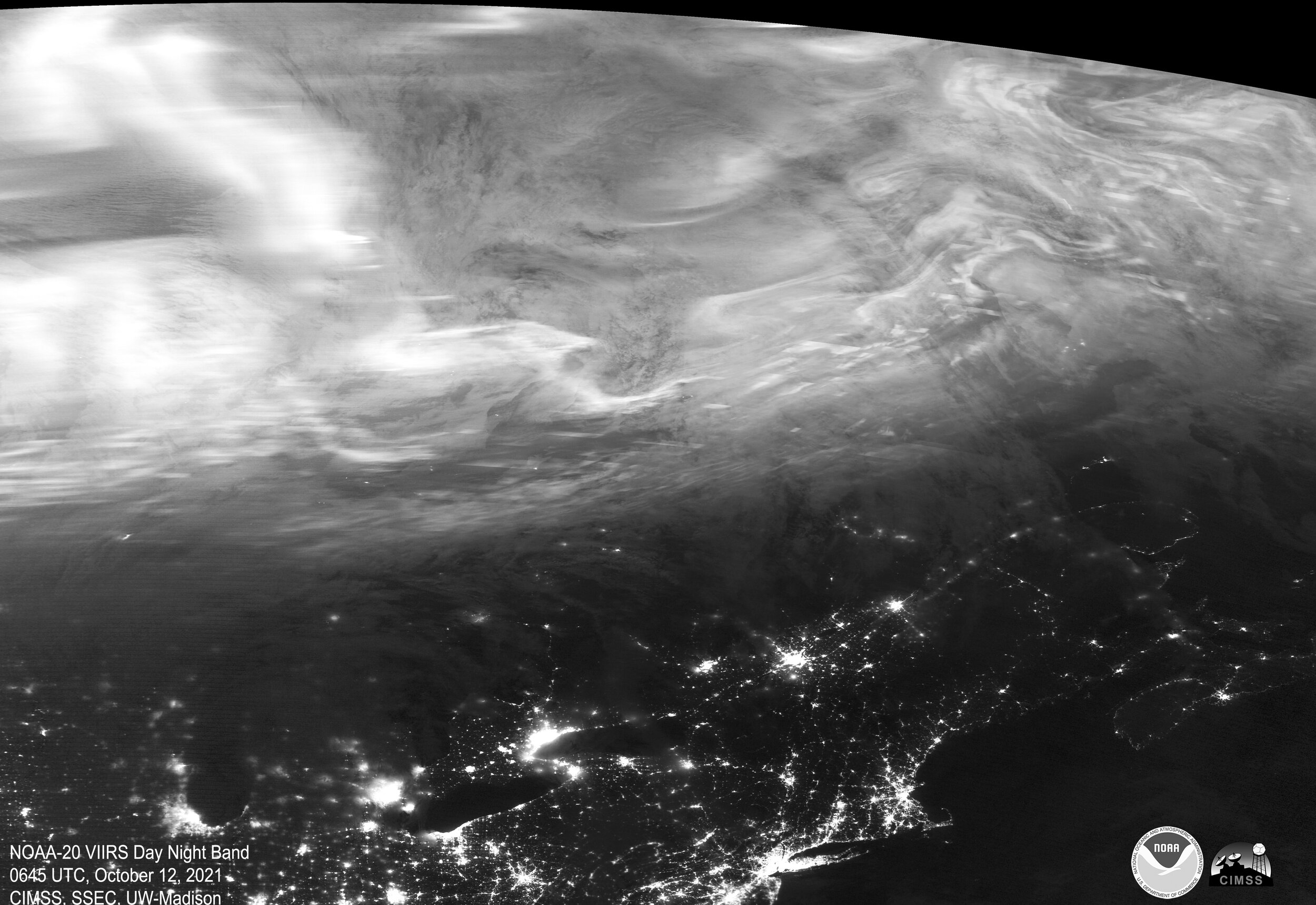
Northern Lights
A Coronal Mass Ejection (CME) hit Earth's magnetic field on Oct. 12th at approximately 02:30 UT sparking a G2-class geomagnetic storm. Auroras spread across northern Europe, Iceland, Canada, and multiple northern-tier US states. The brightest and broadest North America activity was captured by NOAA’s VIIRS satellite system at 1:45am CDT. Image courtesy NOAA/University of Wisconsin-CIMSS
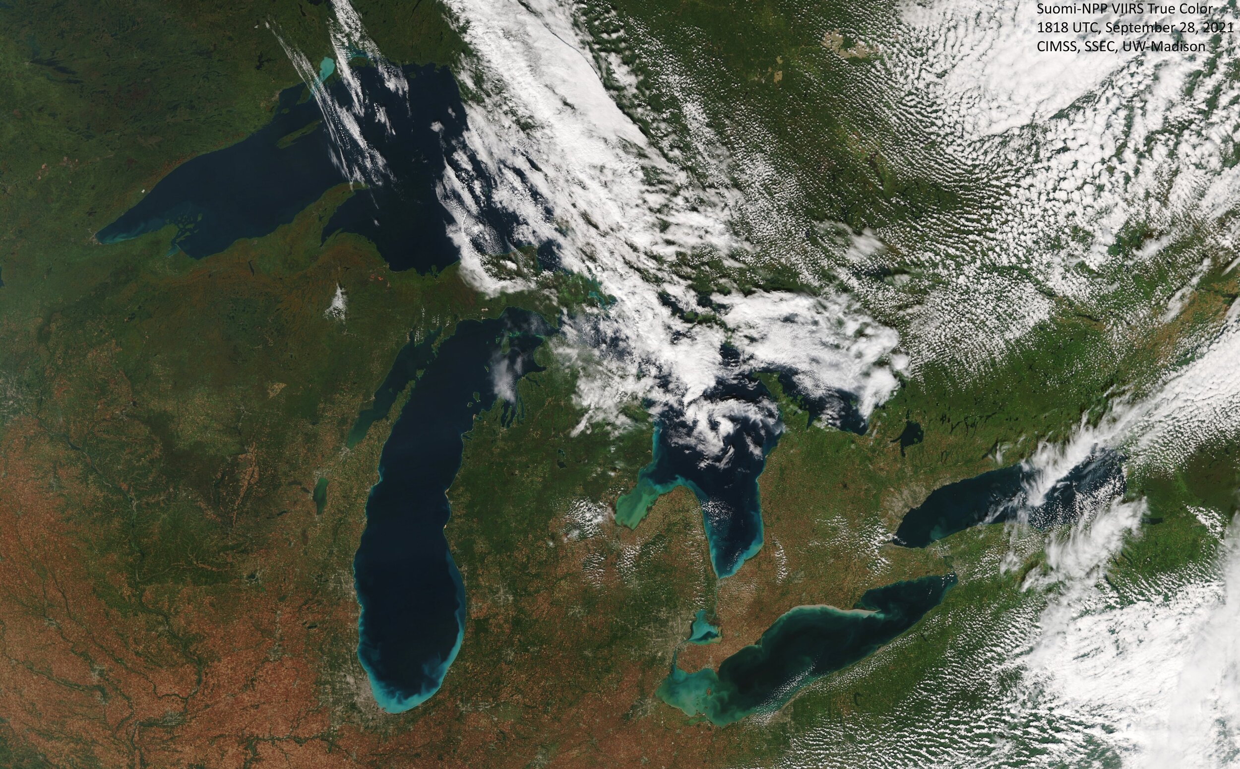
Fall Colors
This is what the Great Lakes looked like Tuesday afternoon, September 28th, when the Suomi-NPP satellite flew over. They’ve been having great weather in that part of the country and classic autumn colors are spreading across the landscape. Image courtesy University of Wisconsin/CIMSS
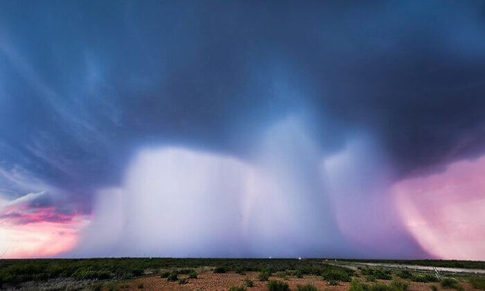
Multiple Microbursts
Texas photographer Mike Olbinski captured this photograph earlier this summer (June 1st, 2021) in the western part of Texas after seeing a wall cloud off in the distance as they were driving back to Lubbock (Texas). “We decided to of course go after it and when we got in front of it, we were thrilled to just be on a good storm finally that day,” Olbinski told The Epoch Times. They positioned themselves south of Andrews (Texas), got out their gear (Olbinski using an extreme wide-angle lens, as the storm would soon literally be on top of them), and witnessed powerful updrafts as the weather evolved before their eyes.
Updrafts—warm, ascending air currents within storm clouds—cause evaporated moisture to rise to cooler altitudes, where it then matures into heavier rain and hail, before plunging down to the earth amid colder airflows. Under the right conditions, warm air currents surrounding the cell can help this process, causing the whole thunderstorm—sometimes miles wide—to collapse in an instant in a massive downward rush of wind, rain, and hail, producing what’s known as a “microburst.”
Distinct from tornadoes, microbursts can be just as destructive with winds sometimes reaching 150 miles per hour. The wind, rain, and hail hit the ground with such force, it has nowhere to go except outwards and can cause devastation in all directions, toppling trees and structures. The supercell on this particular day was about to go microburst ballistic—a “microburst machine,” as Olbinski called it. They witnessed a single, massive column of torrential downpour, at first, with the magnificent colors of a Texas sunset adding to the spectacle. From the sky fell three more pillars of wind and hail, producing a “quadruple microburst”.
Courtesy Mike Olbinski/The Epoch Times
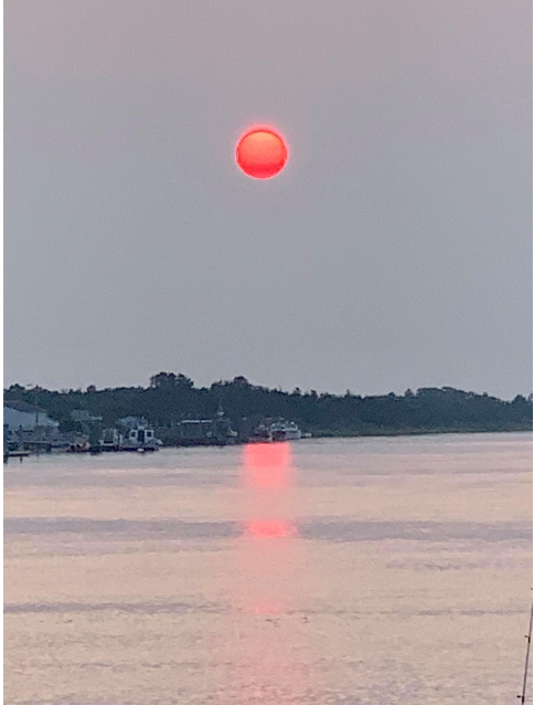
Smoky skies from Canadian wildfires
Smoke-filled skies in the Mid-Atlantic region are being caused by wildfire activity in southern Canada and it can make for a very orange sunset. This photo was taken in Lewes, Delaware on the evening of Monday, July 19, 2021, with brilliant orange colors as a result of sunlight at sunset through a smoky sky.
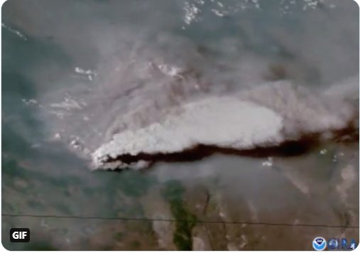
Wildfire in Oregon
Oregon's “Bootleg” wildfire showed explosive growth on the evening of July 14th, 2021 with smoke and pyrocumulus clouds seen by satellite. This is the largest active fire burning in the U.S., and has spread to more than 212,000 acres at last report. Much of the western US is experiencing a hot and dry summer season largely as a result of cooler-than-normal sea surfaces temperatures in the eastern Pacific Ocean as described in the Weather Summer Outlook that was issued in the spring. The wildfire season is likely to remain quite active in the western US as we head through the fall season.
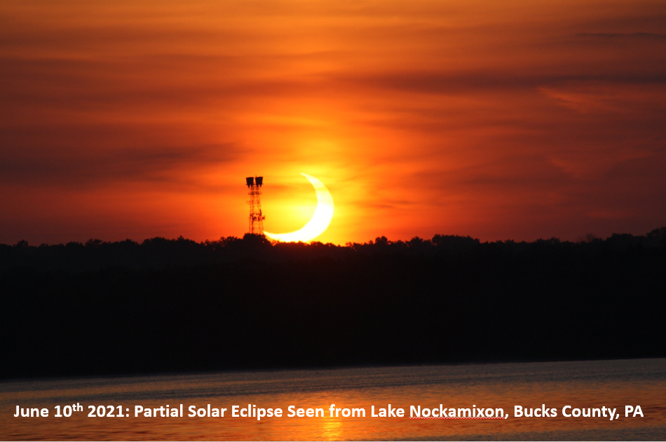
Partial eclipse of the sun
There was a partial eclipse of the sun at sunrise on Thursday, June 10th, 2021 and this photograph was taken in Bucks County, Pennsylvania. Observers in the Northeast US saw a partial solar eclipse, which made the sun look like a glowing orange crescent. [Photo courtesy Andrew Ochadlick].

Clouds on Mars
NASA’s Curiosity Mars rover spotted these iridescent, or “mother of pearl,” clouds on March 5, 2021, the 3,048th Martian day, or sol, of the mission. “If you see a cloud with a shimmery pastel set of colors in it, that’s because the cloud particles are all nearly identical in size,” said Mark Lemmon, an atmospheric scientist with the Space Science Institute in Boulder, Colorado. “That’s usually happening just after the clouds have formed and have all grown at the same rate.” Seen here are five frames stitched together from a much wider panorama taken by the rover’s Mast Camera, or Mastcam. Credits: NASA/JPL-Caltech/MSSS; full story at wattsupwiththat.com
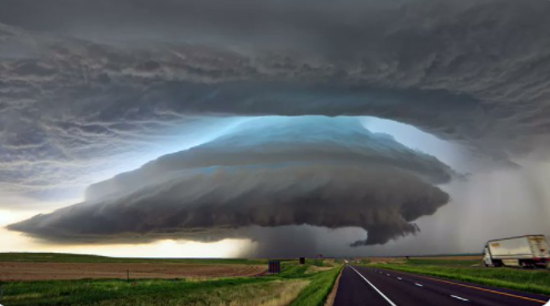
Severe weather in Kansas
This spectacular photograph was taken on Wednesday, May 27th, 2021 in Brewster, Kansas on a day that featured numerous tornadoes. For more specific information on the severe weather in Kansas click here. Photo courtesy Twitter, (Mr Twister)

The return of the cicadas
The cicadas are emerging in the Mid-Atlantic region now that soil temperatures are climbing through the 60’s. Full story on the return of Brood X: Could be a noisy spring! (Photograph from Crofton, MD, May 15, 2021)
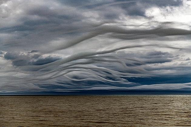
Asperitus clouds over Lake Ontario
The clouds that looked like octopus tentacles over Lake Ontario. "I have never seen anything like it," said photographer James Montanus, who captured the odd looking sky Tuesday, May 4, 2021. Clouds that look like the sea on a windy day are called Asperatus from the Latin verb ‘aspero,' which means to make rough. And they are very rare. "Asperitas, formerly referred to as Undulatus Asperitas, is a distinctive, but relatively rare cloud formation that takes the appearance of rippling waves, according to the WMO’s International Cloud Atlas. Photo credit Montanus Photography
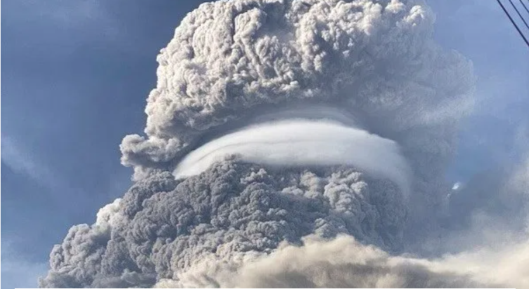
Caribbean volcanic eruption
After days of stratospheric venting, explosive volcanic activity is continuing on the Caribbean island of St. Vincent, with the Volcanic Ash Advisory Center (VAAC) Washington warning of a volcanic ash plume rising to an estimated 44,000 ft (13,400 m). Particulates ejected above 10 km or so – and so into the stratosphere– can shade sunlight and reduce terrestrial temperatures. Smaller particulates can linger in the upper atmosphere for years or even decades at a time. As an example of how far a volcanoes influence can reach, SO2 emissions from La Soufrière (St. Vincent) have now been detected in Africa. (Photograph is from April 13th, 2021)
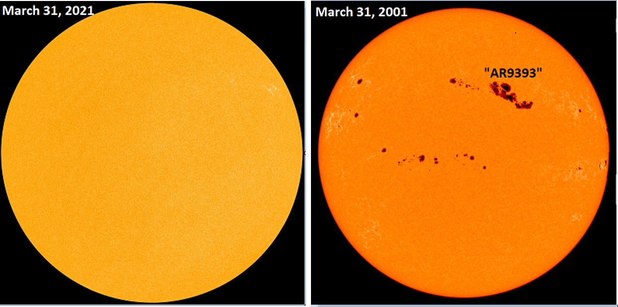
The sun today...the sun twenty years ago
The sun is blank today (left), but it was quite a different story twenty years ago on March 31st, 2001 when it was peppered with sunspots (right). On that particular day, there was an extremely large sunspot known as “AR9393” which was visible to the naked eye and it turned out to be the biggest of Solar Cycle 23. A couple days prior to this image, “AR9393” hurled a couple of coronal mass ejections (CMEs) towards the Earth resulting in an intense geomagnetic storm that actually produced “northern lights” all the way down to Mexico. (Credit to spaceweather.com)
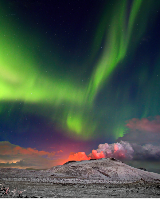
Iceland volcano and the northern lights
A volcano on the island of Iceland broke its silence last week as it erupted on March 19th breaking an extended quiet period of about eight centuries. Lava has been oozing through the ground ever since the eruption which followed weeks of earthquakes. This picture of the northern lights high above the “Fagradalsfjall” volcano was taken late last night, March 24th, after skies cleared following a snow squall in the area. It was the first night with clear skies in the area since the eruption took place last week. Interestingly, historic accounts suggest that whenever this particular volcano has experienced a significant uptick in seismic activity, intermittent eruptions follow for 100 years or so. (Image and information courtesy spaceweather.com)
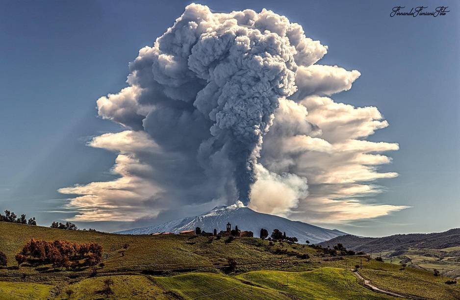
Mt. Etna (Italy) erupts again
Mount Etna, or Etna, is an active stratovolcano on the east coast of Sicily, Italy, in the Metropolitan City of Catania, between the cities of Messina and Catania. It lies above the convergent plate margin between the African Plate and the Eurasian Plate. Etna has had multiple eruptions during the past few weeks and the one on the morning of March 12, 2021 produced a plume of ash and steam that reached approximately 10 kilometers in altitude. The ash and steam column drifted east, causing heavy lapilli and ash fall in places on the eastern sector of the volcano including Milo, Giarre and others. This latest eruption was particularly powerful and rather long-lasting, marking the 12th such event in a row. After a rather slow start, lava fountaining began around 8am local time on March 12th, and increased until reaching a peak phase during 9:30-10:40 am.
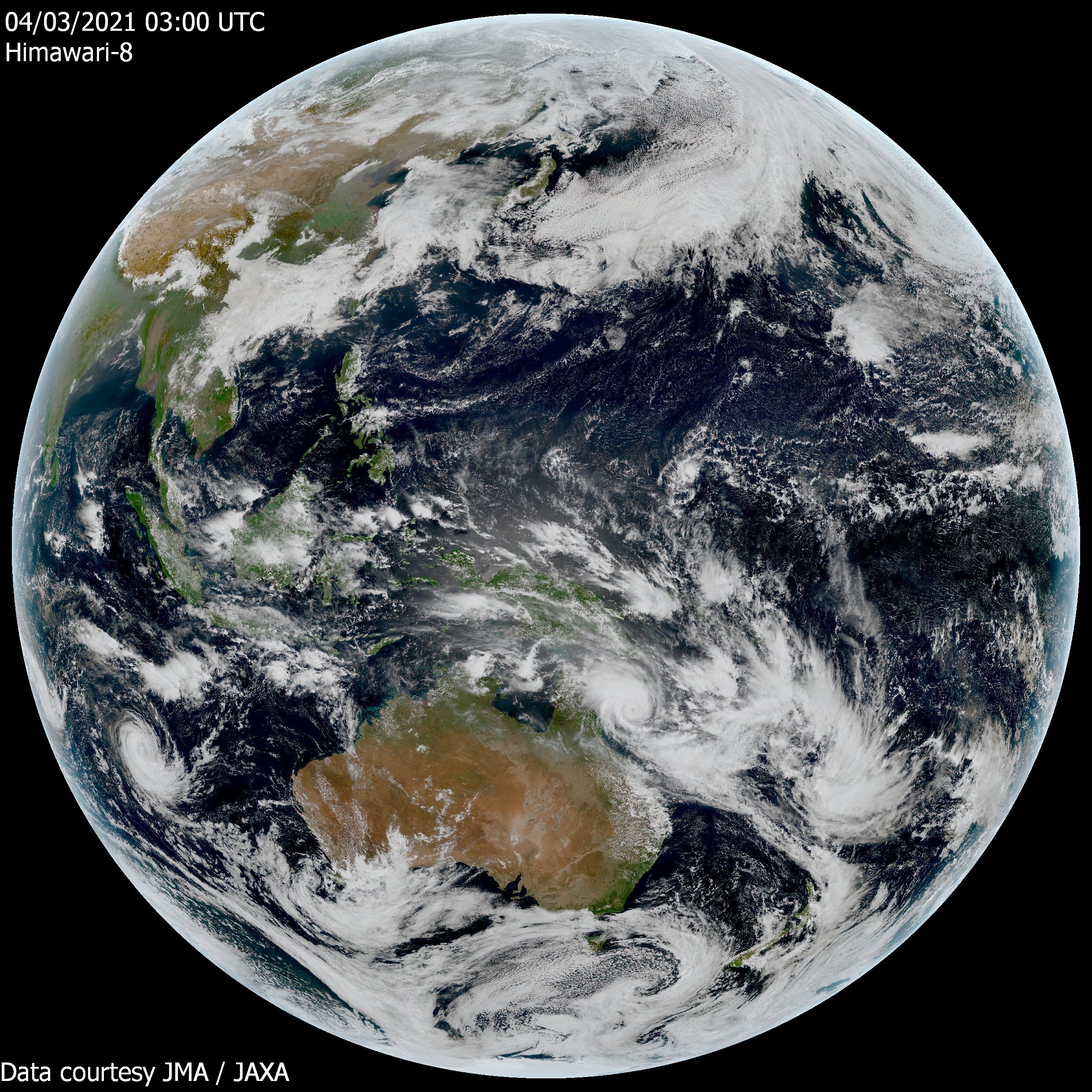
View of the planet
The view from Japan's Himawari satellite on March 4th, 2021..
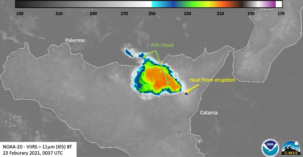
Mount Etna (Sicily, Italy)
Mount Etna, Europe's most active volcano, erupted last night (Feb. 23, 2021) and spewed forth an impressive ash cloud, which could be seen in both the Day-Night Band and infrared bands on NOAA-20. The volcano has been erupting for the past week…no damage or injuries have been reported.
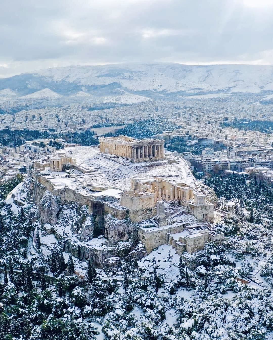
Snow covered Acropolis
A thick blanket of snow has covered the Acropolis in Athens, Greece as a cold spell swept through southern Europe. This is the heaviest snowfall observed in Athens in more than a decade and temperatures plunged to near zero. (February 16, 2021)
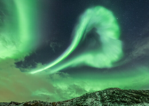
Northern Lights over Norway
The sun has been relatively quiet in recent days, but there was a minor geomagnetic storm over the weekend classified as a “G1”. It produced a dazzling display of northern lights over the Scandinavian countries. This photo was taken on February 8th, 2021 over Norway (credit spaceweather.com).
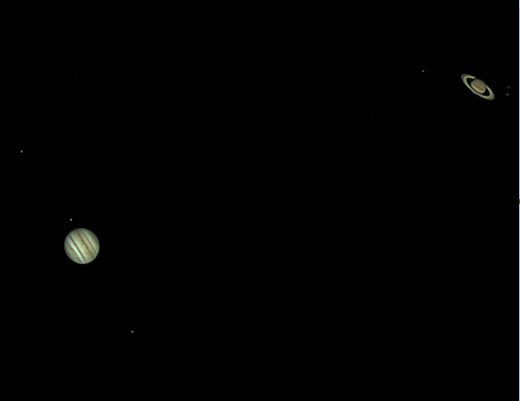
"Great Conjunction" of Jupiter and Saturn
The “Great Conjunction” of Jupiter and Saturn took place on December 21st, 2020 with the two giant gas planets appearing only 0.1 degrees apart from our viewpoint on Earth. It has been nearly 800 years since the two giant gas planets have appeared so close together AND have been so easy to see. Often, the glare of the sun makes their convergence difficult or even impossible to see, but this year is very special because the conjunction happens comfortably away from the sun.
The last time these two gas giants have appeared this close together was in the year 1623 during Galileo’s times, but the sun’s glare that year very likely obscured the pair of planets to sky watchers on Earth. The last time the two giant gas planets appeared so close together AND were so easy to see was during medieval times in March of the year 1226. While Jupiter and Saturn appear quite close together to us in the sunset sky, they are actually about 450 million miles apart from each other. In this photograph taken in Florida through an 8-inch telescope, the largest moons of both planets are visible (photo courtesy spaceweather.com). For more info click here.
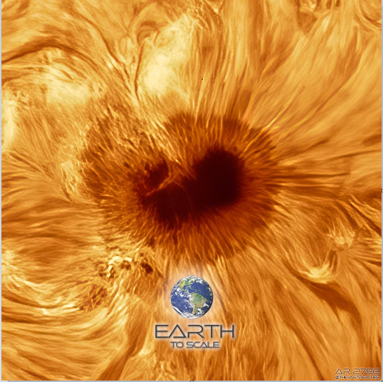
Sunspot as solar cycle 25 gets underway
he NASA Solar Dynamics Observatory (SDO) mission consists of one sun observing spacecraft with three instruments which is located in a geosynchronous orbit around Earth. The AIA and HMI instruments provide us with solar imagery of unprecedented detail. This close-up image from November 30th, 2020 of sunspot AR 2786 is provided by AIA channel 193 which highlights the outer atmosphere of the sun known as the corona. Hot active regions, solar flares and coronal mass ejections will appear bright and dark areas known as coronal holes are places where very little radiation is emitted. Credit for image, info: NASA/SDO/spaceweatherlive.com, Twitter David I Birch, Jason Guenzel (TheVastReaches).
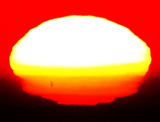
Sunset in Rio
This spectacular sunset took place on October 28th in Rio de Janeiro, Brazil. Air layers of different densities just above the surface of the water severely distorted the image of the sun. Warm air, strong temperature gradients, and at least one temperature inversion sliced the image of the setting sun into multiple shape-shifting layers. Briefly, the sun assumed the form of a mushroom cloud, followed by a sequence of other shapes including a rectangle. Giant sunspot AR2778 (note the black streak, lower left, in the image above) was stretched, compressed, and ultimately obliterated. For a video of the distorted sunset, click here: https://spaceweathergallery.com/indiv_upload.php?upload_id=169209. [Courtesy spaceweather.com]
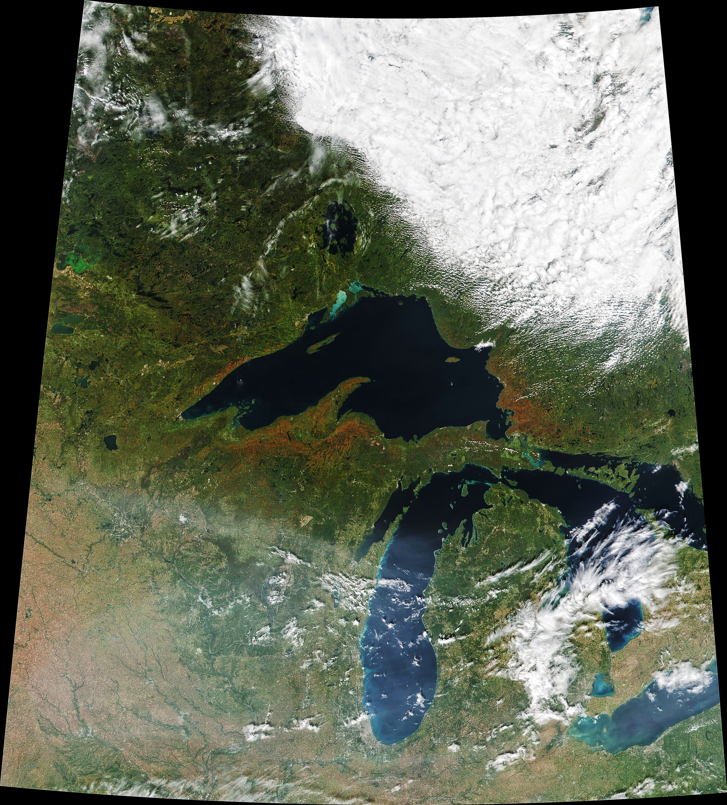
Superior Fall Colors
Minnesota, Wisconsin, and Michigan are typically among the first parts of the contiguous United States to experience autumn color. Fall 2020 was no exception. Aided by a period of chilly weather, fall foliage was peaking in the region’s forests in late September. On September 22, 2020, the Visible Infrared Imaging Radiometer Suite (VIIRS) on NOAA-20 acquired this image of the area around Lake Superior, which is rich with aspen, birch, maple, basswood, and other deciduous hardwood trees. In autumn, the leaves on deciduous trees change colors as they lose chlorophyll, the molecule that plants use to synthesize food. Chlorophyll makes plants appear green because it absorbs red and blue sunlight as it strikes leaf surfaces. It is not a stable compound and plants have to continuously synthesize it to keep their leaves green—a process that requires ample sunlight and warm temperatures. When temperatures drop and days shorten, levels of chlorophyll drop as well. As green chlorophyll fades, other leaf pigments—carotenoids and anthocyanins—show off their colors. Carotenoids absorb blue-green and blue light, appearing yellow; anthocyanins absorb blue, blue-green, and green light, appearing red. As explained by the U.S. Forest Service (https://www.fs.usda.gov/visit/fall-colors/science-of-fall-colors), certain species of trees produce certain colors. Oaks generally turn red, brown, or russet; aspen and yellow-poplar turn golden. Maples differ by species. Red maple turns brilliant scarlet; sugar maple, orange-red; and black maple, yellow. Leaves of some trees, such as elms, simply become brown.
Credit: NASA Earth Observatory image by Joshua Stevens, using VIIRS data from NASA EOSDIS/LANCE and GIBS/Worldview and the Joint Polar Satellite System (JPSS). Text by Adam Voiland.
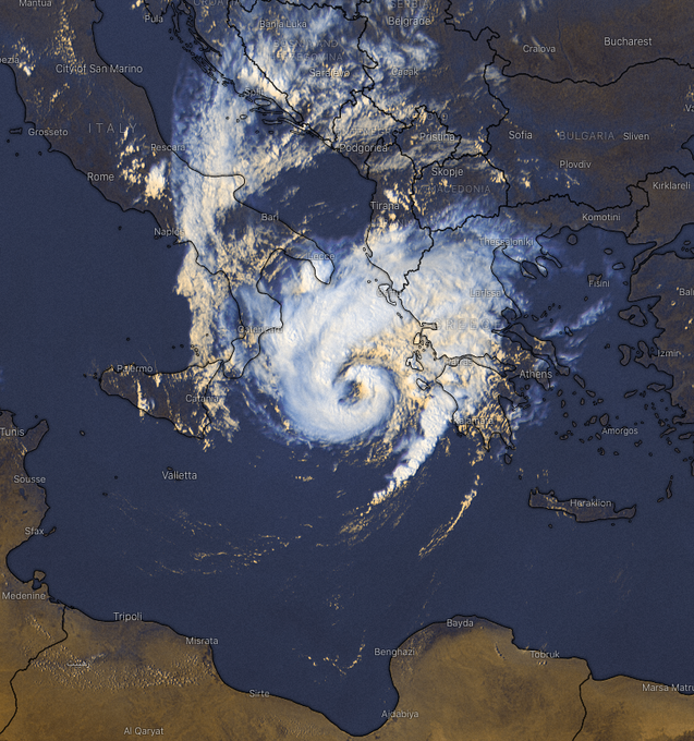
"Medicane"
This Mediterranean hurricane (“Medicane” for short) pushed off of Libya earlier in the week and intensified over the warm waters of the Mediterranean Sea. This system is named “Janus” and has pounded southern Italy and western Greece with strong winds and flooding rains (9/17/20).
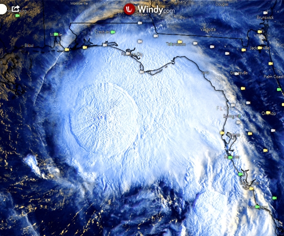
Gravity waves and Tropical Storm Sally
An intense burst of deep convection on Monday, September 14th caused gravity waves to push radially outward from the center of Tropical Storm Sally. This burst of convection is signaling intensification in the inner core region of Tropical Storm Sally which is very likely to result in hurricane status being reached later in the day. (Image courtesy “windy.com”, MJ Ventrice (Twitter) )
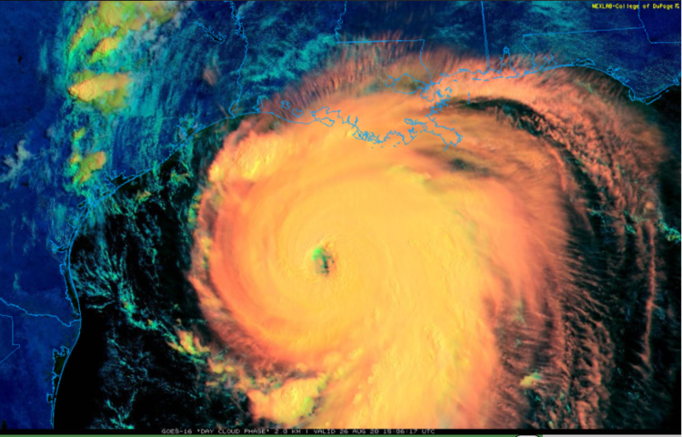
Hurricane Laura
Hurricane Laura came ashore in southwestern Louisiana on Thursday morning, August 27th with an initial estimate of category 4 (“major”) classification. This image from NOAA’s GOES-East satellite is in the “day cloud” phase and it shows clearly the “eye” of Hurricane Laura just a few hours before landfall.
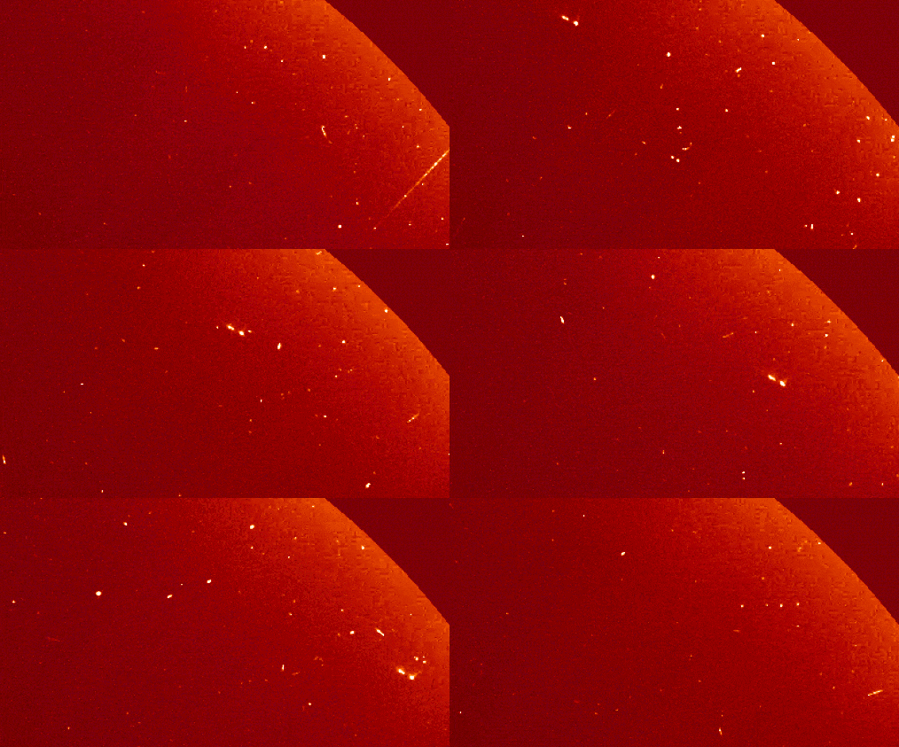
Something Unusual Just Flew Past the Sun
Courtesy spaceweather.com:
On August 7th, an unusual object flew past the sun. "It was a triple comet," says Karl Battams of the Naval Research Lab in Washington DC, who made this animation using coronagraph images from the Solar and Heliospheric Observatory (SOHO). "The two main components are easy to spot, with the third, a very faint, diffuse fragment following alongside the leading piece," he says.
SOHO finds comets all the time. Most are Kreutz sungrazers, fragments of a giant comet that broke up more than 1000 years ago. Since the observatory was launched in 1995, SOHO has discovered more than 3000 members of the Kreutz family dive-bombing the sun. And that's what makes this comet unusual. "It is not a member of the Kreutz family," says Battams. "Its orbit doesn't match. We're not yet sure where it came from."
The triple comet is now receding from the sun, fading rapidly from view. There's a slim chance that large ground-based telescopes might be able to track it. If so, they could find clues to its make-up and origin.
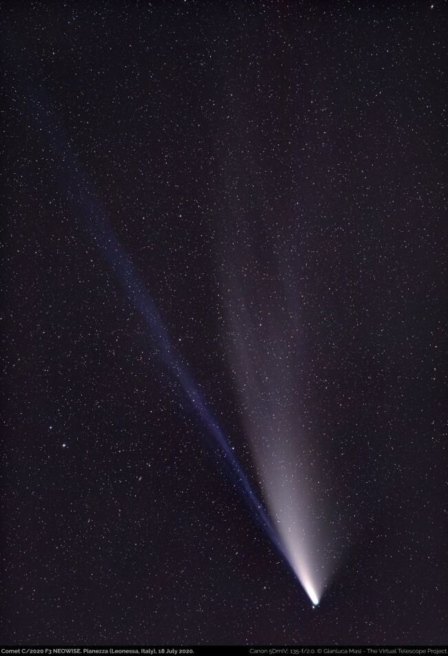
Comet NEOWISE near its closest approach to Earth
Comet NEOWISE will reach perigee or its closest distance to Earth at about 64.3 million miles on Thursday, July 23rd. This photograph was taken on July 18th. The comet has dimmed some in recent days and is generally visible to the naked eye from dark sites only with the best of atmospheric conditions (i.e., low humidity, no clouds).
This comet has certainly not been a disappointment for skywatchers in terms of terms of overall viewing - unlike two comets earlier in the year, ATLAS and SWAN, which disintegrated upon their approach to the sun. Comet NEOWISE won’t be back this way for another 6800 years because of its extremely long, elliptical orbit.
Photo credit: Astrophysicist Gianluca Masi of the Virtual Telescope Project captured this view of Comet C/2020 F3 (NEOWISE) on July 18, 2020. (Image credit: Gianluca Masi/The Virtual Telescope Project, space.com)
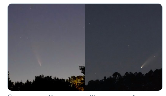
Comet NEOWISE
First, there was Comet ATLAS in April which disappointed sky watchers as it broke apart into pieces. Then there was Comet SWAN in May which also disintegrated. And now we have a third comet named NEOWISE and this one is coming through and could be visible until mid-August. In recent days, this comet has been visible shortly before sunrise, but now, it has become an evening object as well and will actually be visible at both ends of the day for the rest of this week. These photographs were taken over Lancaster County, PA and show the comet before sunrise (left) and after sunset (right). For more info, click here.
!["Noctilucent clouds and Comet NEOWISE" [courtesy ISS]](https://images.squarespace-cdn.com/content/v1/56530521e4b0c307d59bbe97/1594131365140-4V3B58KJUTOQA6PH1CI0/image-asset.png)
"Noctilucent clouds and Comet NEOWISE" [courtesy ISS]
A one-time opportunity for the International Space Station (ISS) to view noctilucent clouds and Comet NEOWISE at the same time. This is the season for noctilucent clouds - the highest clouds visible from Earth - and Comet NEOWISE is rounding the sun and will become more and more visible as we head towards the middle of July. Full posting on noctilucent clouds here: https://www.perspectaweather.com/blog/2020/6/10/1055-am-rare-noctilucent-clouds-the-highest-clouds-seen-on-earth-have-been-unusually-prevalent-in-recent-days and full posting on Comet NEOWISE here: https://www.perspectaweather.com/blog/2020/6/25/1115-am-thursday-a-comet-mayjust-maybe-visible-in-mid-july.

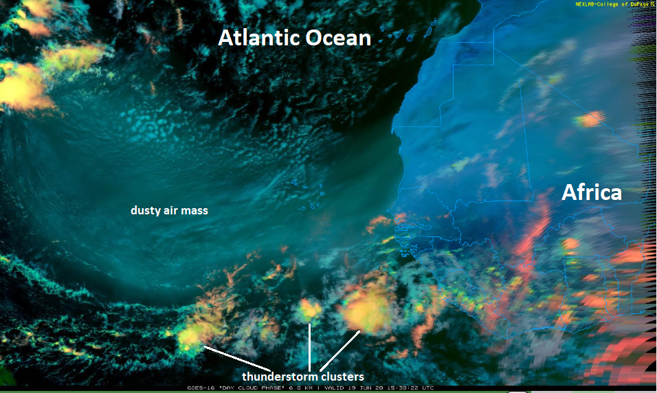
Sahara Desert dust plume
A massive plume of dust from the Sahara Desert of northern Africa is pushing westward over the tropical Atlantic Ocean and towards the southern US. The dry, dusty desert air mass over the tropical Atlantic has a few clusters of thunderstorms on its perimeter to the south and northwest. The air mass that originated in northern Africa several days ago is an inhibiting factor for tropical activity in the Atlantic Basin and it could lead to brilliant (colorful) sunsets in parts of the US early next week. Image on June 19th, 2020 courtesy College of DuPage, NOAA/GOES-16 (“day cloud phase”). Full posting on this interesting atmospheric phenomenon here.

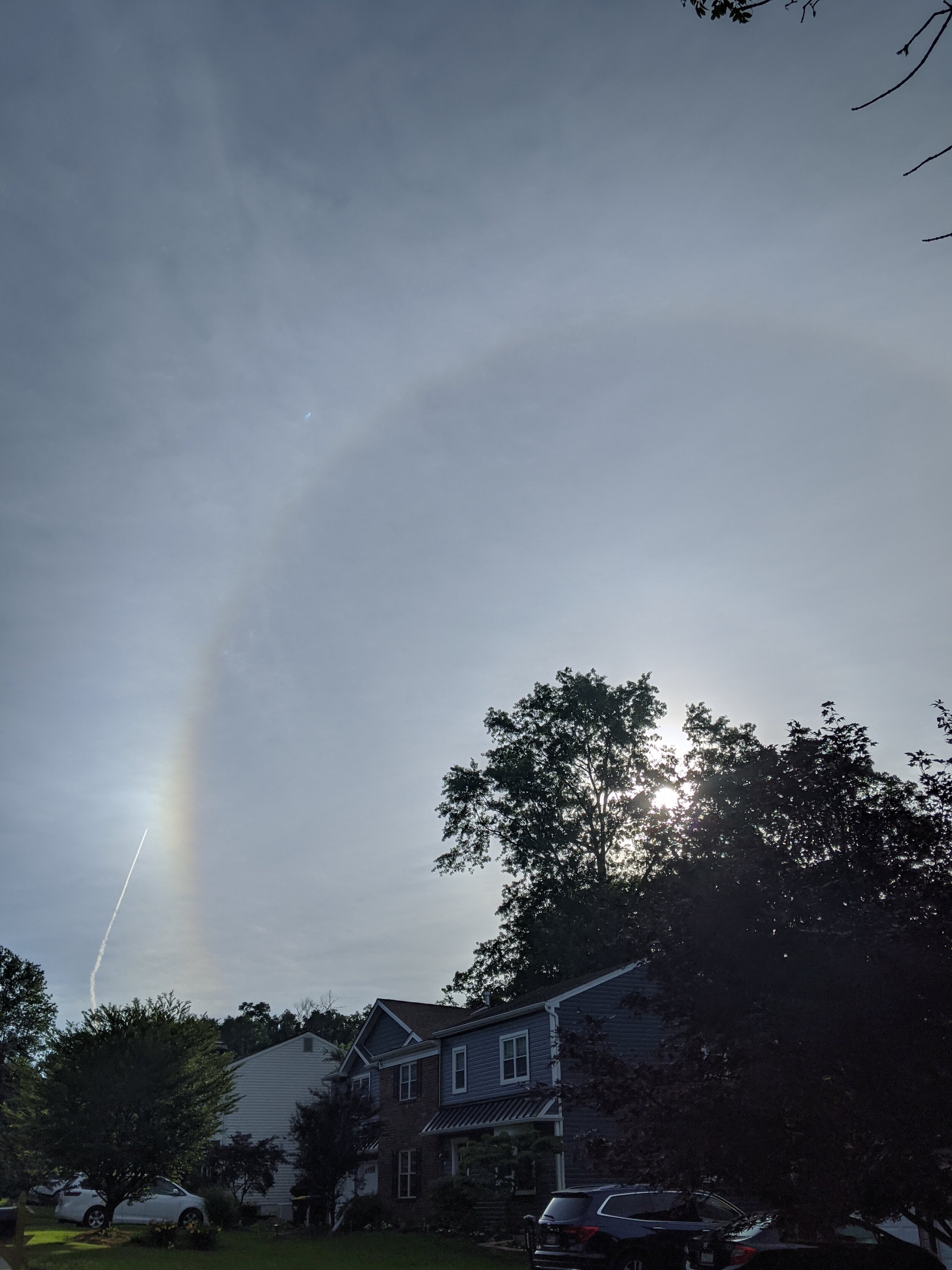
Circular halo around the sun
Tiny ice crystals in high, thin cirrus clouds can create halos around the sun or moon by refracting and reflecting the light. Halos can have many forms, ranging from colored or white rings to arcs and spots in the sky. Many of these appear near the sun or moon, but others can occur elsewhere and even in the opposite part of the sky. Among the best known halo types are the circular halo (properly called the 22° halo), light pillars, and sun dogs, but many others occur; some are fairly common while others are (extremely) rare. This photograph of a circular halo around the sun was taken in East Norriton, Pennsylvania on the morning of Wednesday, June 17th. High clouds pushed into this region on this day ahead of a slowly (northward) moving upper-level low pressure system that has been spinning over the Carolinas in recent days. A contrail can also be seen in the lower, left portion of the photograph. (Credit to John Kelley for the photograph)

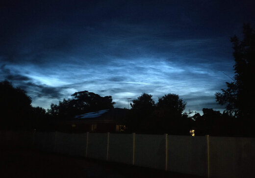
Noctilucent Clouds
Noctilucent clouds are the highest clouds on Earth and are quite rarely seen in the US as they are primarily detected in the higher latitudes above +55°N. NASA’s Aeronomy of Ice in the Mesosphere (AIM) spacecraft first spotted wisps of noctilucent or “night-shining” clouds over the Arctic region in late May. In recent days, however, these clouds have been seen in the continental US (Washington, Minnesota) and the growing chill aloft suggests this summer could be as good or maybe even better than last summer when records were set for low-latitude sightings. In fact, temperatures in recent days in the mesosphere layer of the atmosphere have be the lowest since 2007 when NASA’s AIM spacecraft began monitoring noctilucent clouds. Research studies have shown that these clouds tend to be more prevalent during solar minimums and we have been in the midst of one since last year. This photo was taken in Idaho on Tuesday night, June 9th, 2020 (courtesy spaceweather.com).

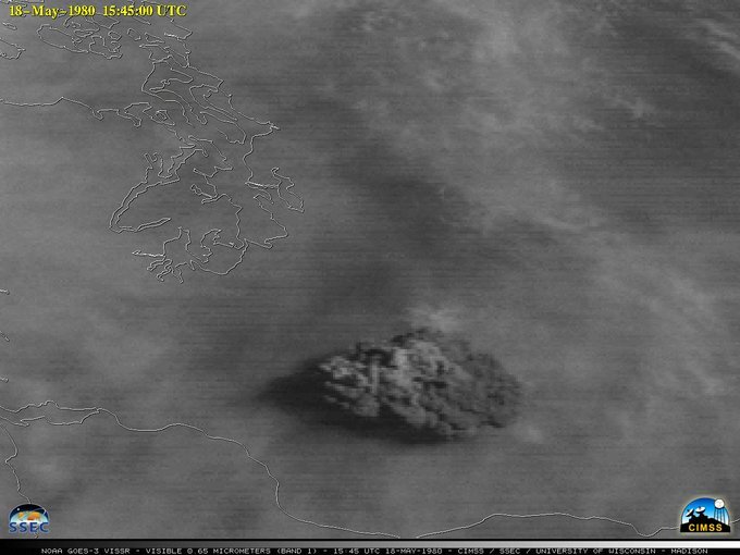
40th Anniversary of the Mt St Helens Eruption
Mt St Helens erupted 40 years ago today. Located between Portland, OR & Seattle, WA, the explosion impacted over a million people & sent an ash plume 15 miles high, captured by GOES-West which was known back then as GOES-3.

Influx of tropical moisture
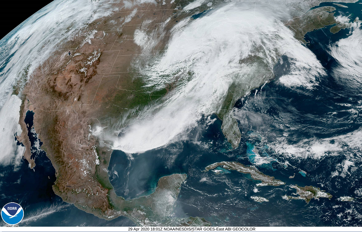
A developing storm system on Wednesday, April 29th, 2020 has quite an influx of moisture feeding into it from the Gulf of Mexico. This system will produce heavy rain in the eastern US over the next 36 hours with additional tropical moisture feeding into the system from the SW Atlantic and Caribbean Sea. (NOAA/GOES-16 satellite image)

Spotless Sun
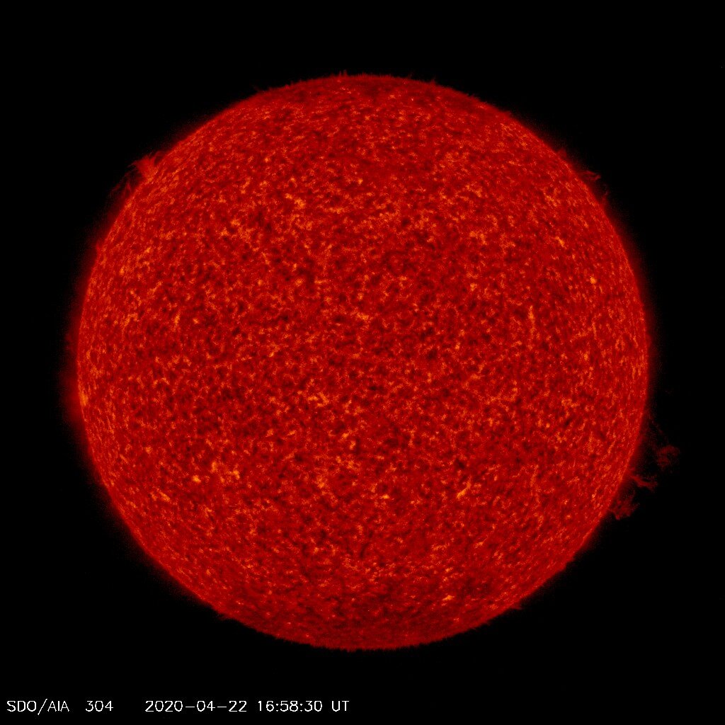
The sun continues to be blank on Wednesday, April 22nd with no visible sunspots and this is the 17th day in a row as we continue progressing through a solar minimum. In fact, the sun has been blank 77% of the time in 2020 which follows 281 days in 2019 or 77% of the time and that was the highest percentage since 1913.

Comet ATLAS
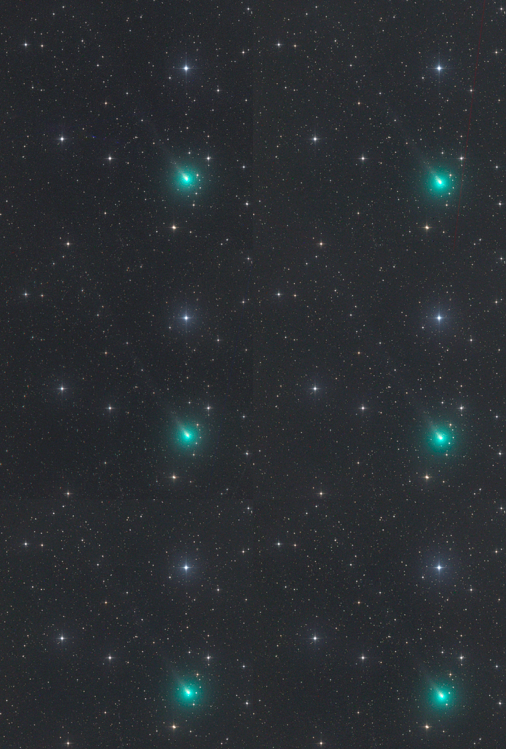
About a month ago, Comet ATLAS was very difficult to find, but it is now as bright as an 8th magnitude star and has generated quite an impressive tail. This brightness is hundreds of times brighter than astronomers predicted when it discovered the comet several months ago. While it is still too dim to see with the unaided eye, it is becoming an increasingly easy target for backyard telescopes. The comet is expected to become much brighter by the time it sweeps by the sun closer than Mercury during late May, it could even rival Venus in the evening sky. (Animation courtesy spaceweather.com, Gerald Rhemann (Austria).

Kelvin-Helmholtz Clouds
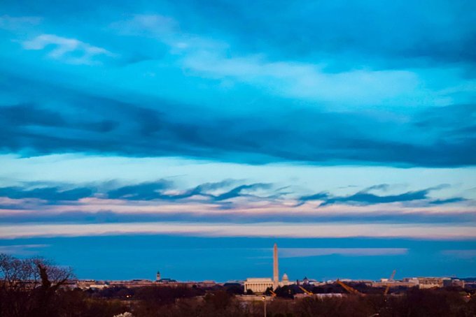
This image of Kelvin-Helmholtz clouds was taken in the Washington, D.C. metro region on Monday, March 9, 2020. These clouds look like breaking ocean waves, with the rolling eddies seen at the top of the cloud layers. The eddies are usually evenly spaced, making the clouds easily identifiable.
Kelvin-Helmholtz clouds are named for Lord Kelvin and Hermann von Helmholtz, who studied the physics of the instability that leads to this type of cloud formation. A Kelvin-Helmholtz instability forms where there’s a velocity difference across the interface between two fluids: for example, wind blowing over water. You’ll often see the characteristic wave structure in this type of cloud when two different layers of air in our atmosphere are moving at different speeds. The upper layers of air are moving at higher speeds and will often scoop the top of the cloud layer into these wave-like rolling structures.
The clouds often form on windy days, when there’s a difference in densities of the air, for example, during a temperature inversion. They’re often good indicators of atmospheric instability and the presence of turbulence for aircraft.

Small-scale snow event in Kansas
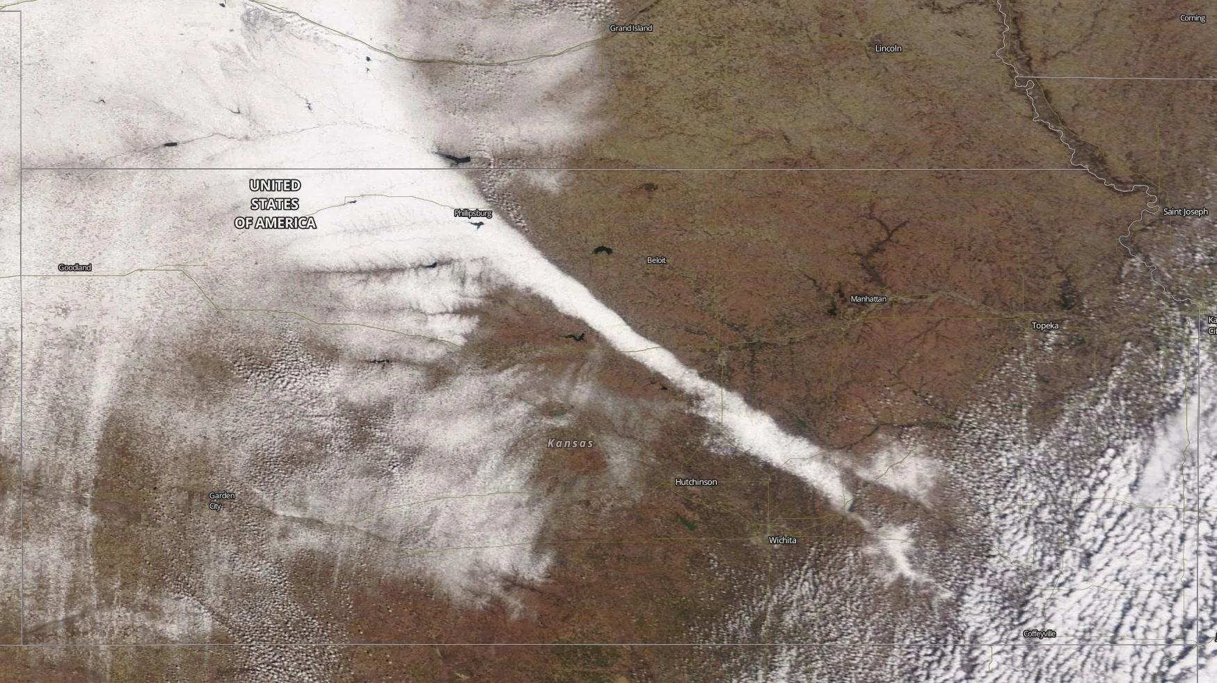
A narrow band of heavy snow blanketed parts of Kansas on Tuesday, February 25, 2020. Up to 13 inches of snow was reported in this band that was only 7 to 15 miles wide. The snowband developed over western Nebraska and northern Kansas on Monday night and continued into Tuesday. Once skies cleared, satellite imagery showed the pencil-thin band from space. It could also be seen from flights over Kansas. The skinny nature of this single band is similar to the width of lake-effect snowbands in the Great Lakes, but unusual for the middle of the heartland.

Powerful Jet Streak over the North Atlantic
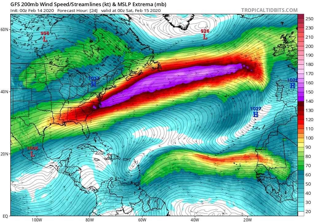
On Feb. 8, 2020, British Airways Flight 112 (BA 112) rocketed from New York to London in a mere 4 hours 56 minutes, at one point traveling faster than 825 mph. It did this by surfing the jet stream. A couple of very strong storms in the North Atlantic in recent days have been associated with powerful jet streaks aloft. Another one of these powerful jet streaks will develop on Friday night and persist into Saturday, February 15th in the same region if this prediction comes true by the latest run of NOAA’s GFS computer forecast model.

North Atlantic Storm
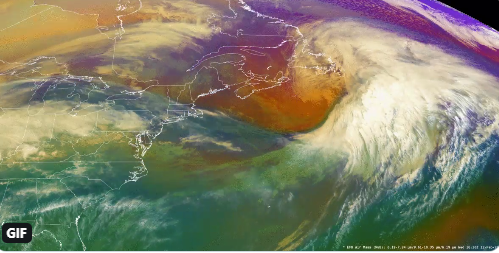
Rapidly intensifying low pressure clipping southern Newfoundland on Wednesday, February 12 is forecast to deepen 46 millibars over the next 24 hours into the central Atlantic. Marine hazards next 24 hours include hurricane-force winds to 80 knots, significant wave heights increasing to near 50 feet.

Volcanic eruption in the Philippines
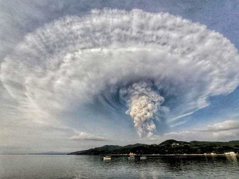
Forty-three years after its last eruption, the Taal volcano in the Philippines roared back to life and sent steam, ash and pebbles 9 miles high on January 12, 2020. Lava gushed from the volcano and forced villagers to flee and resulted in a shut-down of Manila’s international airport. Clouds of ash blew more than 60 miles to the north reaching the capital of Manila. Taal underwent frequent eruptions in the mid-1960’s and then again in 1977 (both solar minimum time periods). In 2006, 2008, 2010 and 2011, the volcano periodically trembled with earthquakes and occasionally showed increased hydrothermal activity (superhot liquids seeping to the surface), all reminders that Taal remained an active volcano. Image Credit: Kenji Cheow / Facebook from from Anilao, Batangas

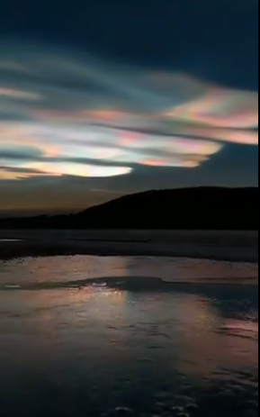
Polar Stratospheric Clouds
Normally, the stratosphere has no clouds at all as it is an extremely dry layer in Earth’s atmosphere. Every once in awhile, however, it gets so cold up there that the sparse water molecules can actually assemble themselves into icy clouds. Conditions for the past couple of days have been conducive to the formation of such clouds as it is extremely cold in the stratosphere over the Arctic Circle with temperatures as low as -85 degrees (C). As a result, there has been an outbreak of these polar stratospheric clouds and some reports suggest they are more prevalent than ever filling as much as 25% of the sky. (Image from Sweden on December 31, 2019)

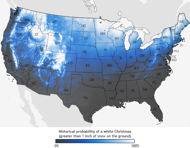
White Christmas
Historical probability of a white Christmas across the USA (greater than one inch; source NOAA).

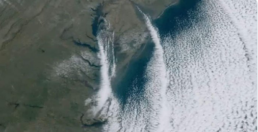
Cold air flowing over warm water generating "clouds streets"
On Wednesday November 13th, 2019, Arctic air was flowing from NNW-to-SSE across the Delaware and Chesapeake Bays in the Mid-Atlantic region. As the very cold air moved over the still relatively-warm waters beneath, instability was generated in the lower part of the atmosphere and “cloud streets” formed parallel to the wind flow (i.e., from NNW-to-SSE). The “cloud streets” can then take on a flattened-appearance if they run into some warmer and more stable air aloft which acts as a lid. The inversion causes the rising thermals to “roll over” on themselves forming parallel cylinders of rotating air. The clouds streets may start a bit offshore as the cold air mass needs some time and distance moving over the water to pick up enough moisture for clouds to form. Some of these clouds are likely to have ultimately produced snow flurries or snow showers out over the warm waters of the western Atlantic Ocean.

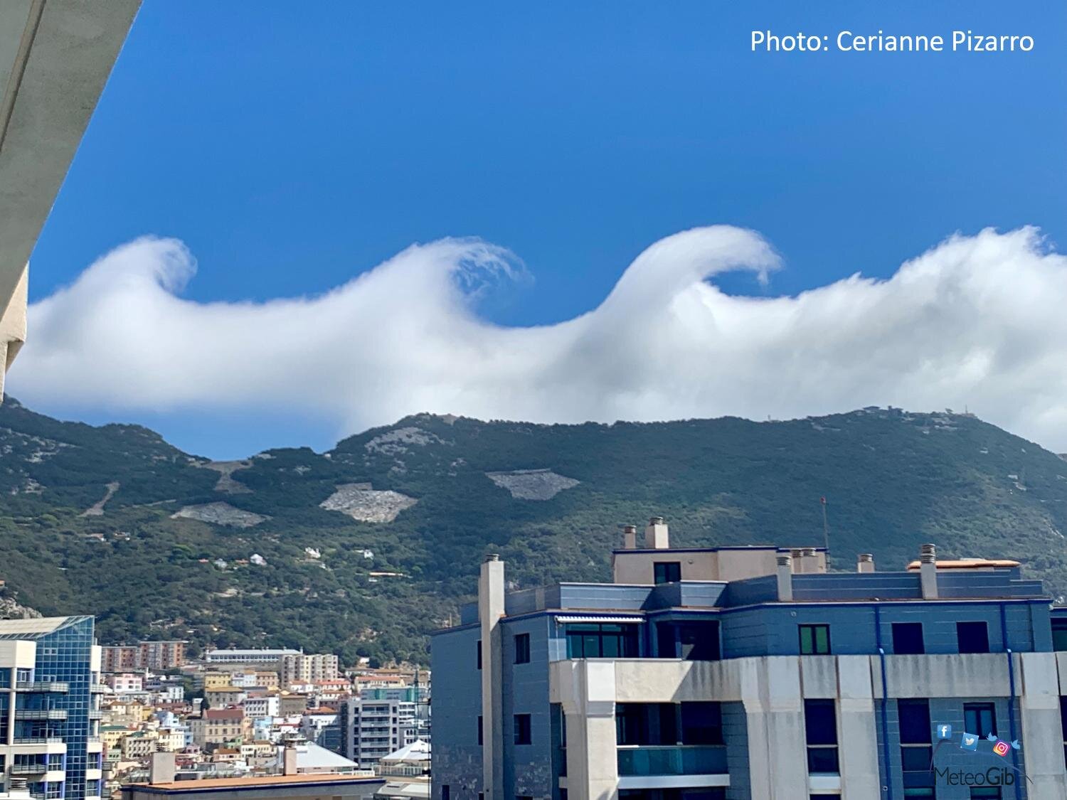
Kelvin-Helmholtz wave clouds
Gibraltar is a British Territory on Spain's south coast and is dominated by the Rock of Gibraltar, a 426 meter-high limestone ridge. This is a great photo of rare Kelvin-Helmholtz wave clouds seen on September 26th, 2019 caused by wind shear in the flow over the Rock of Gibraltar. Kelvin-Helmholtz clouds are named for Lord Kelvin and Hermann von Helmholtz, who studied the physics of the instability that leads to this type of cloud formation. The upper layers of air are moving at higher speeds and will often scoop the top of the cloud layer into these wave-like rolling structures. (Photo courtesy Cerianne Pizarro, MeteoGib (twitter)).

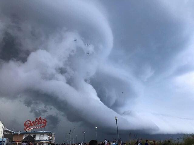
Shelf cloud over Rehoboth Beach, Delaware
This photo was taken in Rehoboth Beach, Delaware on Monday, August 19th in a very unstable atmosphere. There is a moist outflow from one storm with a shelf cloud being lifted by the updraft of another storm. A shelf cloud is a low-hanging, well-defined wedge-shaped formation that occurs along the leading edge of a gust front in a thunderstorm. Shelf clouds most often form just ahead of intense lines of thunderstorms.

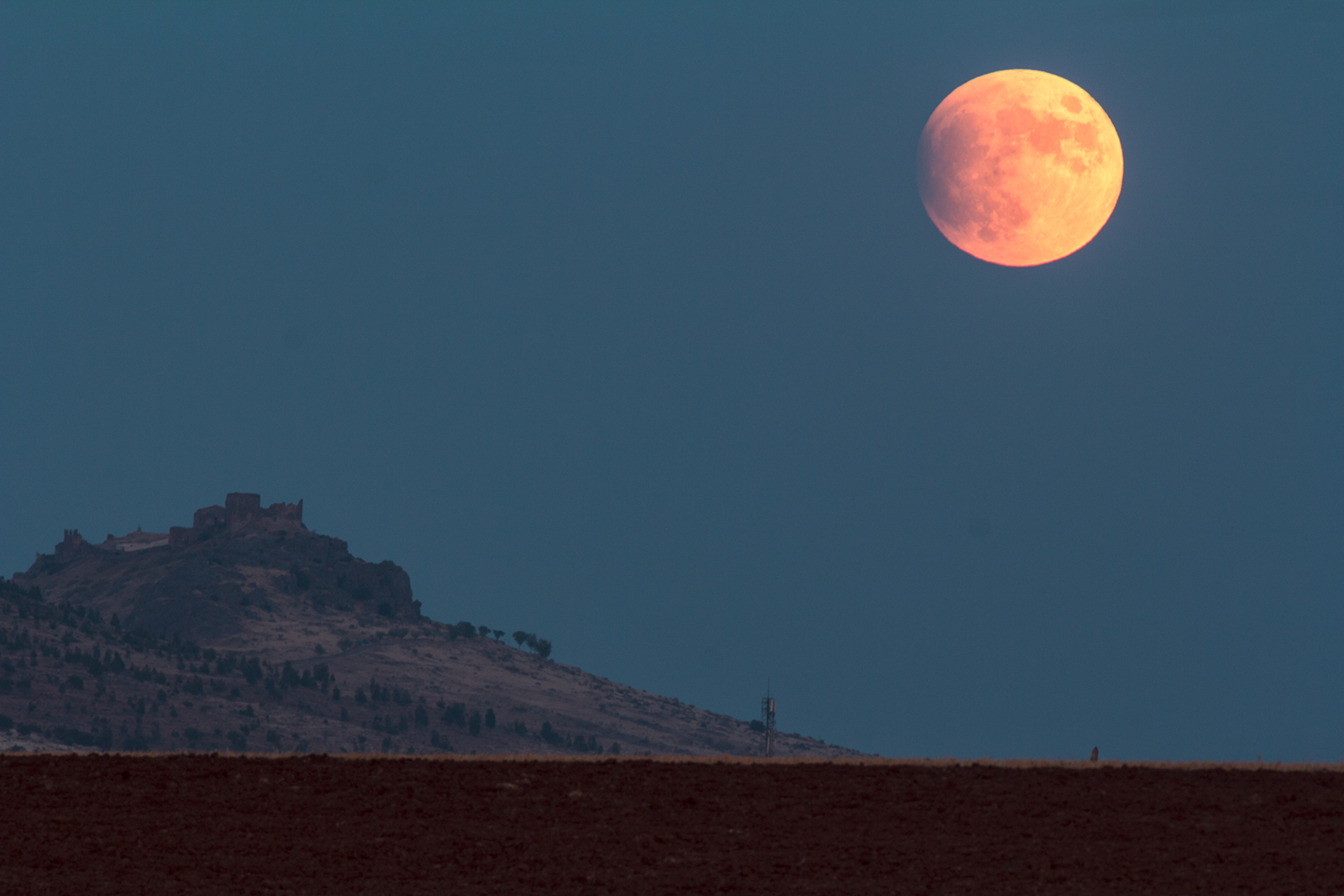
Partial eclipse of the moon
On July 16th, 2019, the full Moon passed through the shadow of Earth, plunging as much as 65% of the lunar disk into darkness. Only a small amount of the Moon was shadowed and sky watchers in Africa, Europe, Asia, Australia and South America saw at least part of the 3 hour event - only North Americans were excluded. The next significant lunar eclipse won't happen until May 2021. Image courtesy spaceweather.com (Alange Castle in southern Spain, photographer Juan Manuel Pérez Rayego).

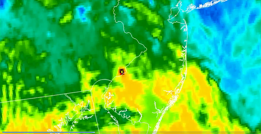
Refinery explosion in Philly captured by satellite
The Key West National Weather Service noticed that the refinery explosion in Philadelphia last Friday (6/21/19) was captured on satellite. The heat signature is so large and hot it could be detected using infrared imagery.
.The blaze at the Philadelphia Energy Solutions Refining Complex, the East Coast's largest oil refinery, was extinguished Saturday afternoon, fire department and city officials said in a statement Sunday.
Credit: NOAA


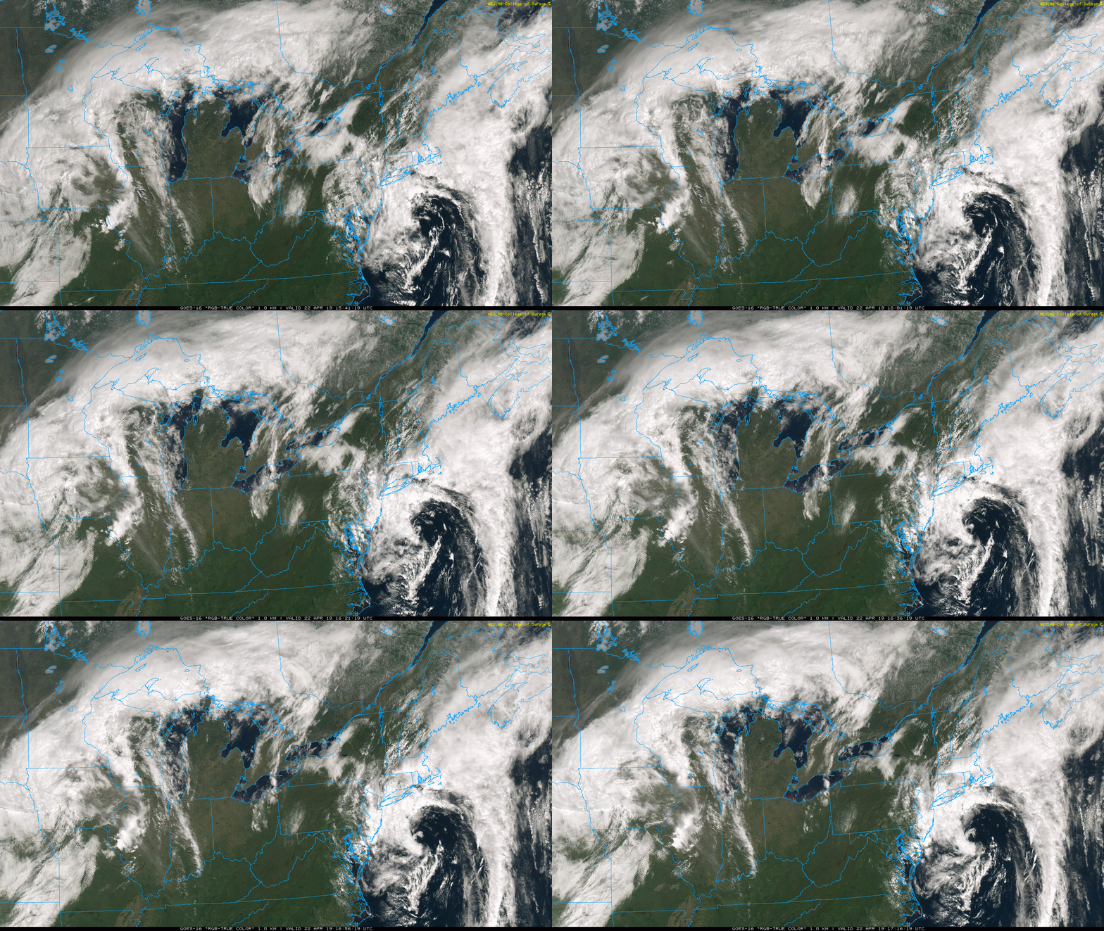
The formation of a coastal low
Deep upper-level low pressure has pushed off the Mid-Atlantic coastline on Monday, April 22nd and it is spawning the formation of a coastal storm. This developing storm will impact the NYC metro region and New England with rain and perhaps even as far to the south and west as the Philly metro region.

April Nor'easter
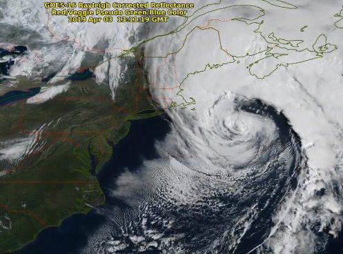
GOES-16 satellite image on April 3 features an April Nor’easter which pounded the eastern part of New England and only skirted the DC-to-Philly-to-NYC corridor. Image courtesy NOAA

California Blooming
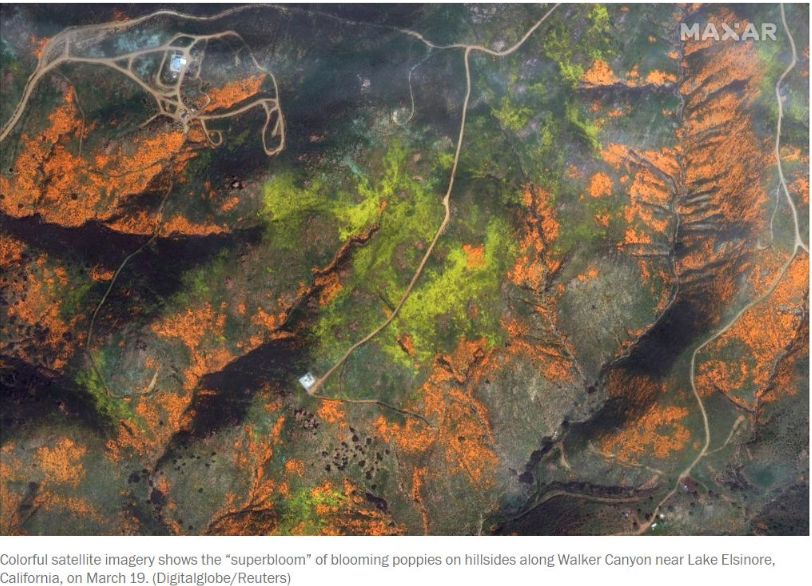
Thanks to heavy rain and snow this winter season, many colorful flowers are blooming in California and they can be seen in this satellite image (March 20, 2019, courtesy Digital Globe, Capital Weather Gang twitter)

Sierra Nevada snow
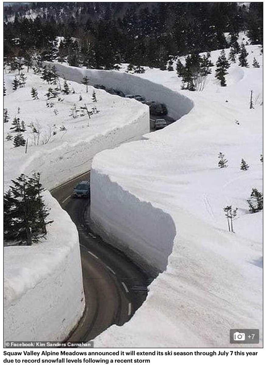
Incredible footage shows driver passing through 41 FEET of snow near Lake Tahoe in Sierra Nevada (March 10, 2019). A driver passing through a road near Lake Tahoe filmed the captivating scene as huge walls of snow were split in parts on either side of the road. Squaw Valley Alpine Meadows announced it will extend its ski season through July 7 this year due to record snowfall levels following a recent storm. Officials claimed the area had exceeded the 50-foot mark at Squaw Valley's upper mountain on Friday, while several other resorts have gone over 500 inches for the season.

Great Lakes ice cover
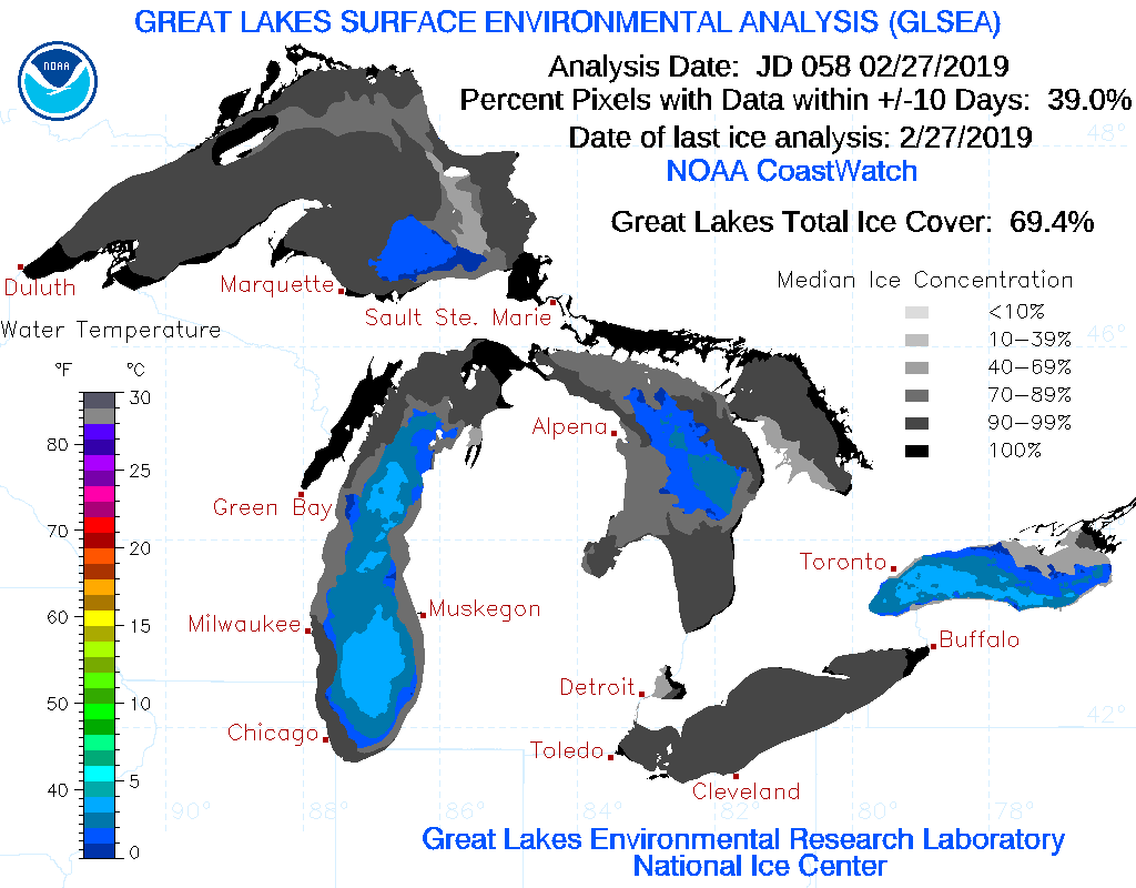
Great Lakes ice cover extent has increased dramatically in recent days thanks to an intrusion of Arctic air. The ice cover content has increased to nearly 75% (as of March 3, 2019) and it is likely to increase further in coming days as the unusual cold spell continues.

Ice coverage on Lake Erie
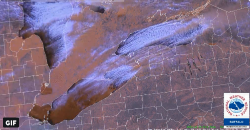
A color enhanced image from GOES-16 on January 31, 2019 shows significant ice coverage over Lake Erie. Ice and snow have a "red" hue here, while clouds have a tinge of "blue".

Total lunar eclipse/supermoon
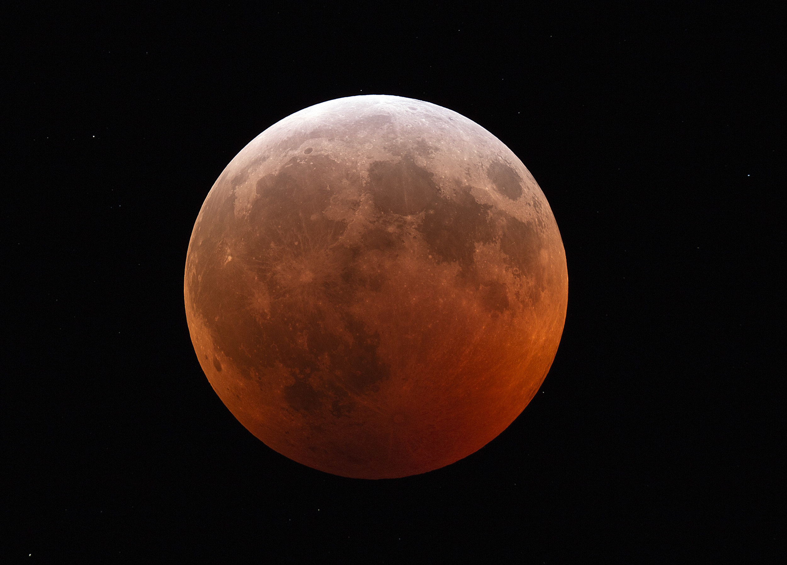
On Sunday, January 20th, 2019, there was a supermoon and a total lunar eclipse visible in both North and South America. An Arctic air mass in the Mid-Atlantic/Northeast US made for very cold viewing conditions, but the air was also very dry which improved the clarity of the moon during this space event.

Pacific Storm
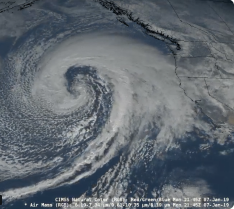
GOES-17 satellite imagery features a monstrous storm over the Pacific Ocean which is producing near hurricane-force winds (January 7th, 2019). Wave heights of up to 45 feet have been analyzed near this powerful system.

Comet 46P/Wirtanen
Known as the green “Christmas comet”, even the northern lights over Norway could not prevent it from being seen on Monday night, December 17th, 2018.

Deep snow pack in North Carolina/Virginia
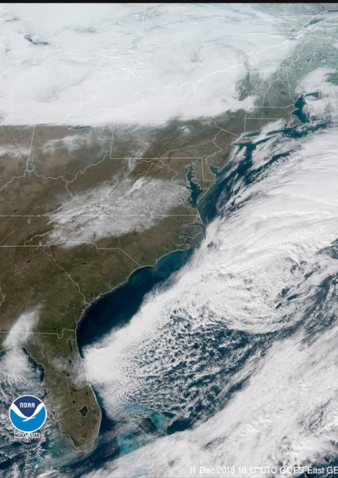
A GOES-East satellite image reveals the deep snow pack that still remains across much of western North Carolina and southern Virginia. Clouds can be seen off the east coast and over the Great Lakes, but clear skies over the snow pack allow for great viewing today, Wednesday, December 12th.

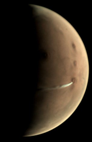
Interesting cloud on Mars
Since 13 September, European Space Agency’s Mars Express has been observing the evolution of an elongated cloud formation hovering in the vicinity of the 20 km-high Arsia Mons volcano, close to the planet’s equator.
In spite of its location, this atmospheric feature is not linked to volcanic activity but is rather a water ice cloud driven by the influence of the volcano’s leeward slope on the air flow – something that scientists call an orographic or lee cloud – and a regular phenomenon in this region.
The cloud can be seen in this view taken on 10 October by the Visual Monitoring Camera (VMC) on Mars Express – which has imaged it hundreds of times over the past few weeks – as the white, elongated feature extending 1500 km westward of Arsia Mons. As a comparison, the cone-shaped volcano has a diameter of about 250 km.
Mars just experienced its northern hemisphere winter solstice on 16 October. In the months leading up to the solstice, most cloud activity disappears over big volcanoes like Arsia Mons; its summit is covered with clouds throughout the rest of the martian year.

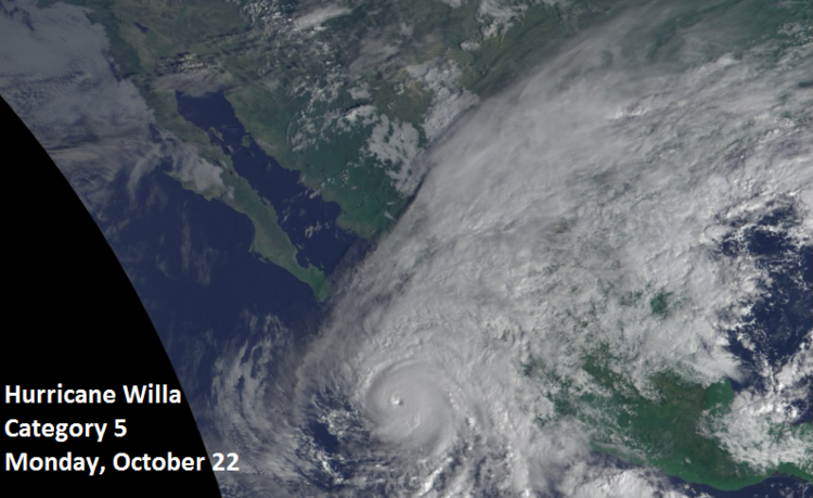
Cat 5 Hurricane Willa
Hurricane Willa has strengthened into a cat 5 storm as of Monday, October 22, 2018 and it will actually play a role in a potential nor’easter this weekend by feeding energy and moisture into the Gulf of Mexico region. Hurricane Willa is likely to weaken into a category 2 or 3 storm before making landfall in Mexico over the next couple of days.

Lenticular Clouds
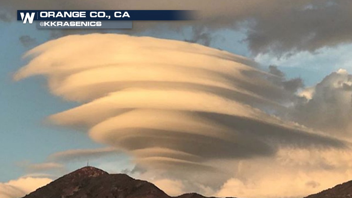
These spectacular lenticular clouds were seen in California on Sunday, September 30th, 2018. Lenticular clouds are stationary clouds that form in the troposphere, usually in perpendicular alignment to the wind direction. As air travels along the surface of the Earth, obstructions are often encountered. These include both natural features of the Earth such as mountains or hills, and man-made structures, such as buildings and other structures. These disrupt the flow of air into "eddies", or areas of turbulence influenced by these obstructions. When moist, stable air flows over a larger eddy, like those caused by mountains, a series of large-scale standing waves form on the leeward side of the mountain. If the temperature at the crest of the wave drops below the local dew point, moisture in the air may condense to form lenticular clouds. (info from Wikipedia; credit for image to “Weather Nation” - twitter)

ISS view of California wildfires
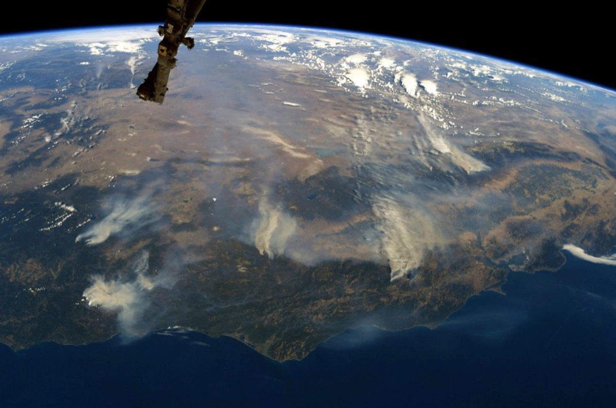
The view of the California wildfires from the International Space Station (August 6, 2018).

California Wildfire
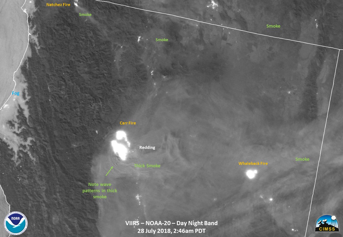
GOES NOAA-20 VIIRS day/night band captures this “hot spot” associated with the CarrFire in northern California on July 28, 2018. The full moon provided ample illumination to see the smoke billowing from the wildfires.

Wildfires in Athens
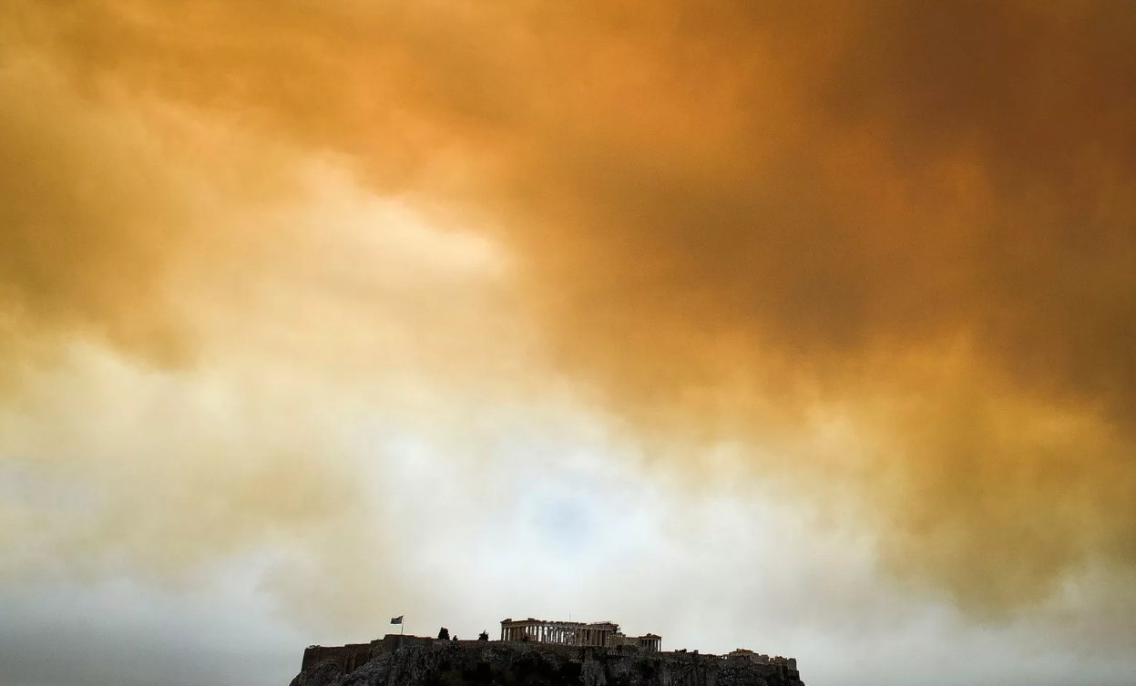
The sky has turned orange around the Parthenon in Athens, Greece as a result of wildfires in the region. The winter was dry and high winds in recent days are fanning the flames of two separate fires: one to the west of the city in pine forest regions and to the northeast of the city in coastal towns. [Image from Monday, July 23, 2018; courtesy AFP/Getty Images]

Rainbow effect in a cloud
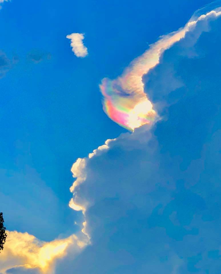
This optical phenomena is caused by tiny ice crystals diffracting light; hence, the rainbow effect. (Algoma, MS on July 3rd, 2018)

"Saharan Dust" on June 14, 2018
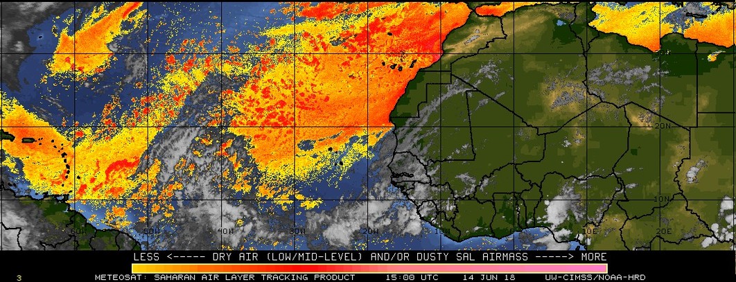
This product from the University of Wisconsin/CIMSS shows the extent of Saharan dust (dry) air over the Atlantic Ocean that is inhibiting tropical storm formation in the Atlantic Basin. This dry air moves in a general east-to-west fashion with the trade winds and can play a critical role in the development or intensification of tropical systems in the Atlantic Basin. In addition to this widespread extent of dry air from the western regions of Africa, sea surface temperatures have been running at below-normal levels in the eastern Atlantic and inhibiting tropical storm formation.

Snow in the Alps
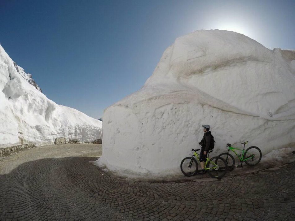
A little bit of snow this winter/spring in the Julian Alps of northwest Slovenia. This photograph taken on Sunday, April 8th, 2018 in a location just a few miles from the northeast border with Italy.

Orange Snow
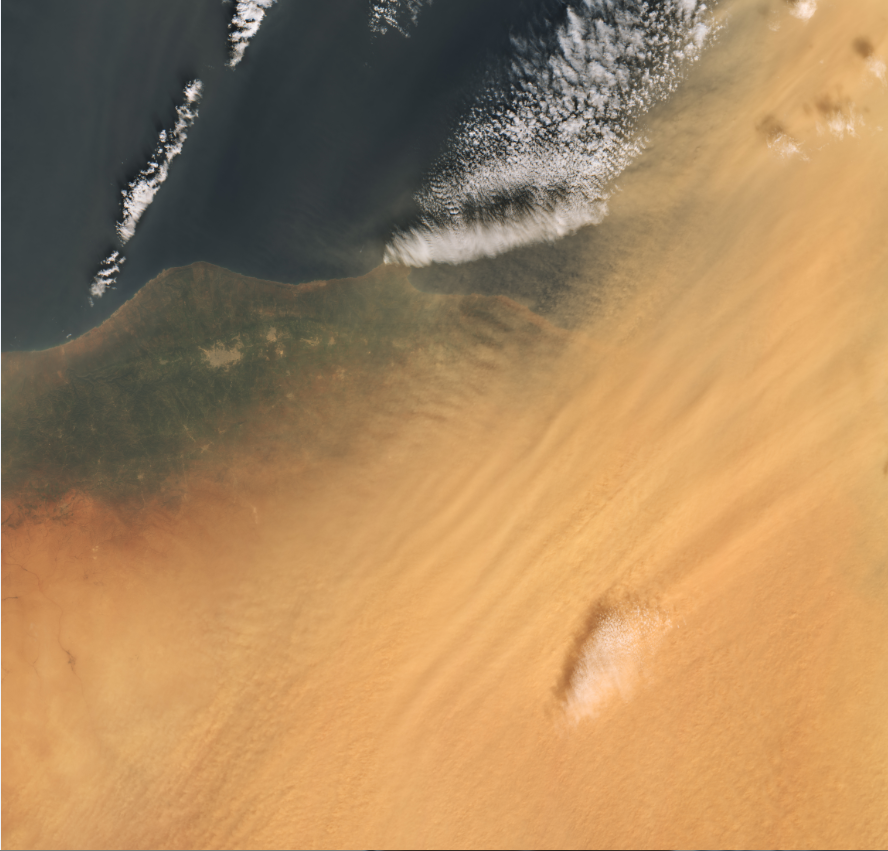
There was orange-tinted snow on Friday, March 23, 2018 in parts of eastern Europe and it also occurred over the weekend. The rare phenomenon is caused by sand from Sahara Desert storms that gets mixed into the precipitation associated with these systems. It happens roughly once every five years or so, but concentrations of sand are higher than usual this time. This MODIS image is of the northeast coast of Libya.

Thunder snow
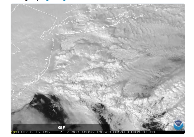
GOES-East got a nice close-up of convective clouds that were part of the second major nor'easter in 5 days for the Northeast US (March 7, 2018). This convection actually resulted in "thunder snow" for many parts of New Jersey and New York City during the height of the coastal storm. (Image courtesy NOAA)

"UFO" cloud lands on Mount Hood, Oregon
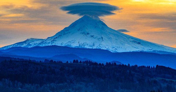
Lenticular clouds (Altocumulus lenticularis in Latin) are stationary clouds that form in the lwoer atmosphere, typically in perpendicular alignment to the wind direction. They are often comparable in appearance to a lens or "saucer" and have been often mistaken for UFOs. This particular lenticular cloud formed on February 8th, 2018 over Mount Hood in Oregon which stands 11, 250 feet tall.on February 8, 2018
Image credit: Washington Post/Capital Weather Gang

Sudden Stratospheric Warming (SSW)
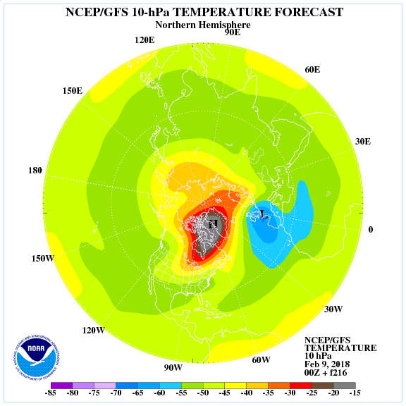
This 216-hour forecast map by NOAA's GFS computer model of stratospheric temperature anomalies features a dramatic rise in 10-millibar temperatures on the North America side of the North Pole (map is "top-down" view of the Northern Hemisphere with the North Pole in the center). Sudden Stratospheric Warming (SSW) events are among the most impressive dynamical events in the physical climate system. If history is any guide, this unfolding stratospheric warming event can result in Arctic air outbreaks for the central and eastern US in coming days.
During the winter months in the polar stratosphere, temperatures are typically lower than minus 70°C. The cold temperatures are combined with strong westerly winds that form the southern boundary of the stratospheric polar vortex which plays a major role in determining how much Arctic air spills southward toward the mid-latitudes. This dominant structure is sometimes disrupted in some winters or even reversed. Under these circumstances, the temperatures in the lower stratosphere can rise by more than 50°C in just a few days. This sets off a reversal in the west-to-east winds and the collapse of the polar vortex.
In response to the stratospheric warming (and associated layer expansion) at the high latitudes, the troposphere in turn cools down dramatically (with layer contraction) at the high latitudes. This tropospheric cold air can then be transported from the high latitudes to the middle latitudes given the right overall weather pattern (e.g., "high-latitude blocking"). The tropospheric response to the SSWs closely resembles the negative phase of the North Atlantic Oscillation (NAO), involving an equatorward shift of the North Atlantic storm track; extreme cold air outbreaks in parts of North America, northern Eurasia and Siberia; and strong warming of Greenland, eastern Canada, and southern Eurasia (Thompson et al., 2002). The entire process from the initial warming of the stratospheric at high latitudes to the cooling in the troposphere at middle latitudes can take weeks to unfold.

Pennsylvania snow cover as seen from space
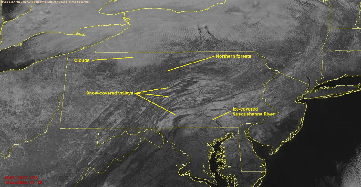
GOES-16 with an absolutely stunning view of Pennsylvania's snow-covered topography on Thursday, January 18, 2018.

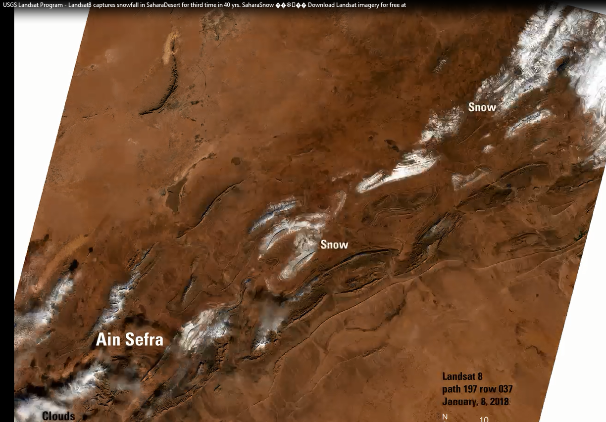
Sahara Desert snow
Landsat 8 captures snowfall in the Sahara Desert for just the third time in 40 yrs. Snow has fallen in the Sahara, covering desert dunes in a layer up to 40 cm deep. Snow started falling on the Algerian town of Ain Sefra in the early hours of Sunday morning, January 7, 2018, giving children an opportunity to race each other down the slopes. Rising temperatures meant it began to melt later in the day. It is the third time in nearly 40 years the town, known as “The Gateway to the Desert”, has seen snowfall.

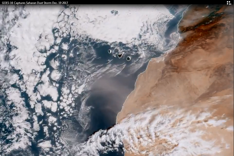
Dust Storm
This GOES-16 satellite image captures a dust storm (center of image) on December 19th, 2017 over the western edge of the Saharan Desert and the eastern Atlantic Ocean. Dust storms are caused by strong winds passing over the loose particles of sandy soils, causing them move over the ground and fracture, freeing smaller particles -- i.e., the dust -- that become airborne and transported by the wind. Scientists estimate that, on average, about 20 teragrams of dust are suspended in the atmosphere at any given time and, about half of it is thought to originates in North Africa, due to both the abundance of dust sources there and the region's position under the subtropical jet stream, which carries dust around the world. The rest is said to come from just a handful of other well-known dust-producing regions, including northwestern China’s Taklimakan Desert, parts of Arabia, Iran, the shore of the Caspian Sea, the Lake Eyre Basin in Australia, and the area around Utah’s Great Salt Lake.
Credit: NOAA/CIRA

First snowfall of the season in the eastern states
MODIS imagery (right) depicts the snowcover from the Saturday, December 9th, 2017, storm with snow all the way down into the Deep South. The actual NOAA snowcover map on the left displays the same strip from the Deep South into the Northeast US.

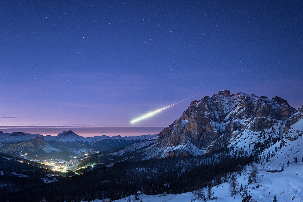
Autumn Fireball
On 14 November 2017 at about 16:45 GMT a football-sized meteoroid entered Earth’s atmosphere about 50 km northeast of Darmstadt, Germany. It created a bright fireball in the sky, which was seen by thousands of people in Germany, France, Switzerland, Austria and Luxembourg, and was reported widely by media.
This remarkable image was taken by Ollie Taylor, a photographer from Dorset, UK, who happened to be on a shoot in Italy, in the Dolomites. The landscape scene shows the village of La Villa, Alta Badia, with Ursa Major seen in the background sky.
At dusk on 14 November, he was setting up for a night landscape shoot at Passo Falzarego, at 2200 m altitude, in clear but chilly –6ºC weather.
Ollie reports: “I was composing a shot of this scene and Ursa Major, seen above the meteor. I wanted to get it at twilight so the sky had a nice pink hue. I just decided I was not getting close enough, and was reaching for my other camera with a longer lens, luckily I left this camera exposing!
“It was a stroke of luck, as it’s given me not only the meteor, but great landscape background, too.”
Small lumps of rock enter our atmosphere every day, but it is rare for one to burn so brightly and to be seen by so many people.
“Owing to the meteoroid’s very high speed, estimated to be at least 70 000 km/h, it super-heated the air molecules in its path as it decelerated, creating a very luminous fireball,” adds Rudiger Jehn, of ESA’s Space Situational Awareness programme.
“Observers reported the meteoroid in detail, which allowed us to estimate its final fate: burning up at an altitude of around 50 km above Luxembourg.”
By yesterday, over 1150 sightings had been submitted to the International Meteor Organization, which runs a website to gather sightings of such events worldwide.
[Courtesy European Space Agency, Ollie Taylor]

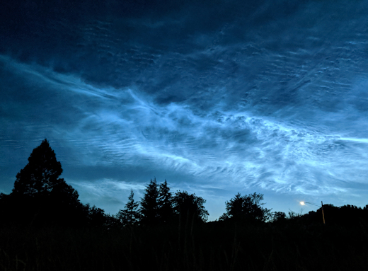
Noctilucent Clouds
Noctilucent clouds are the highest clouds on Earth and are quite rarely seen in the US as they are primarily visible at high latitudes above +55°N. This weekend, however, noctilucent clouds were seen across many spots in the US including as far south as Freedom, Oklahoma (+36°N) which according to spaceweather.com, may be the lowest latitude sighting ever. Research studies have shown that these clouds tend to become more prevalent during solar minimums and we are now entering into what is likely to be a deep and perhaps historic solar minimum.
"I have never seen clouds like this before!" says Tucker Shannon, who took this picture on June 8th, 2019 from Corvallis, Oregon (courtesy spaceweather.com).


!["Noctilucent clouds and Comet NEOWISE" [courtesy ISS]](https://images.squarespace-cdn.com/content/v1/56530521e4b0c307d59bbe97/1594131365140-4V3B58KJUTOQA6PH1CI0/image-asset.png)
