**Some accumulating snow in the Mid-Atlantic from later Friday into early Saturday…coldest air mass yet to follow...a look ahead to early January and a cold pattern**
Paul Dorian
Low pressure over the ocean on Friday will intensify as it pushes to the north and east and it will develop an inverted trough that will extend from the center of the low to the Mid-Atlantic coastline. This inverted trough can lead to enhanced upward motion (convergence) and an increased chance for some snow banding later tomorrow, tomorrow night, and early Saturday morning. Map courtesy NOAA, tropicaltidbits.com
Overview
The combination of a weakening “clipper” low pressure system and an intensifying ocean low that is to develop an inverted trough will raise the chance of some accumulating snow from later tomorrow into early Saturday across parts of the Mid-Atlantic region. There can be a coating to as much as 2 or 3 inches of snow by early Saturday across portion of eastern PA, much of New Jersey, and the New York City metro region and a coating of snow is possible as far south as the DC metro region. As the intensifying ocean low exits off to the northeast on Saturday, the door will be open for the coldest air mass of the season to ride into the Mid-Atlantic region on stiffening NW winds. A look ahead to early January suggests there will be the return of “high-latitude blocking” across Canada which tends to favor colder weather in the central and eastern US and teleconnection indices support the notion of an overall colder weather pattern.
Snow threat in the Mid-Atlantic from later tomorrow into early Saturday
A “clipper” low pressure system that will produce several inches of snow today across portions of the Northern Plains drops southeast into the Ohio Valley by mid-day Friday albeit in a weakened form. At the same time, low pressure over the western Atlantic Ocean will begin to intensify as it heads in a general northeastward direction on Friday and this system will become the main player for the region as it develops an inverted trough of low pressure that will extend westward to the Mid-Atlantic coastline from the ocean low center. The end result will be rain and/or snow shower activity in the Mid-Atlantic region early tomorrow and then snow showers are likely and maybe even a period of steadier snow from later tomorrow into early Saturday. Accumulations of a coating to as much as 2 or 3 inches of snow are possible by early Saturday across eastern PA, much of New Jersey, and the New York City metro region, and a coating of snow is even possible as far south as the DC metro region.
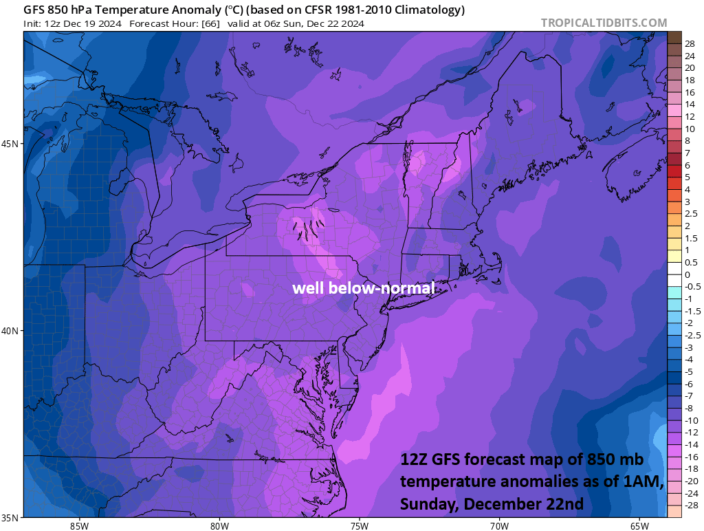
The coldest air yet this season will ride into the Mid-Atlantic/NE US this weekend on the heels of some late week/early weekend snowfall. Map courtesy NOAA, tropicaltidbits.com
Coldest air yet to follow
As the ocean low intensifies and pulls to the northeast on Saturday, the coldest air mass so far this season will ride into the Mid-Atlantic region on stiffening NW winds. The first of its kind college football playoff game at noon on Saturday in Penn State’s Beaver Stadium will be played under mainly cloudy skies with temperatures confined to the low-to-mid 20’s for afternoon highs and a stiff NW wind will make it feel even colder than the actual air temperature. Sunday is likely to turn out to be the coldest day so far this season throughout the Mid-Atlantic region with temperatures confined to the 20’s during the day despite plenty of sunshine and low temperatures by early Monday morning can be pretty close to the 10-degree mark in some suburban locations to the north and west of the big cities.
The 00Z Euro longer-range outlook (i.e., 15 days out) of 500 mb height anomalies suggests “high-latitude blocking” will return to Canada by early January (shown in purple, orange) at the same time an upper-level trough of low pressure retrogrades back to the west and into the eastern US (shown in blue). This kind of pattern would favor colder and stormier conditions in the early part of January across much of the central and eastern states. Map courtesy ECMWF, tropicaltidbits.com
Looking ahead to next week and beyond and a potential flip back to colder
After a generally warmer-than-normal Christmas week across the nation, the overall pattern looks like it will flip back to colder-than-normal for the central and eastern US during the first week of January. Signals point to the return of “high-latitude blocking” across northern Canada by the early part of January and at the same time an upper-level trough of low pressure may retrograde from the Atlantic Ocean back to the eastern US. Some of the computer forecast models (e.g., Euro) predict this type of pattern change by early January and teleconnection indices such as the Arctic Oscillation (AO) tend to support the idea. This index along with its closely related cousin, the North Atlantic Oscillation (NAO), are predicted to take a downturn into “negative” territory by the new year which is usually correlated with the formation of “high-latitude blocking”.
A teleconnection index known as the Arctic Oscillation drops well into “negative” territory by the end of the month (forecast shown in red) and this is often correlated quite well with the formation of a “high-latitude blocking” pattern which, in turn, favors the transport of cold air masses from northern Canada into the central and eastern US. Data courtesy NOAA/GEFS
Meteorologist Paul Dorian
Arcfield
arcfieldweather.com
Follow us on Facebook, Twitter, YouTube
Video discussion:


