3:30 PM | ***Heavy rain event for the DC-to-Philly-to-NYC corridor from late Tuesday night into Wednesday evening...powerful winds, thunderstorms may accompany the heavy rain...cold blast to follow***
Paul Dorian
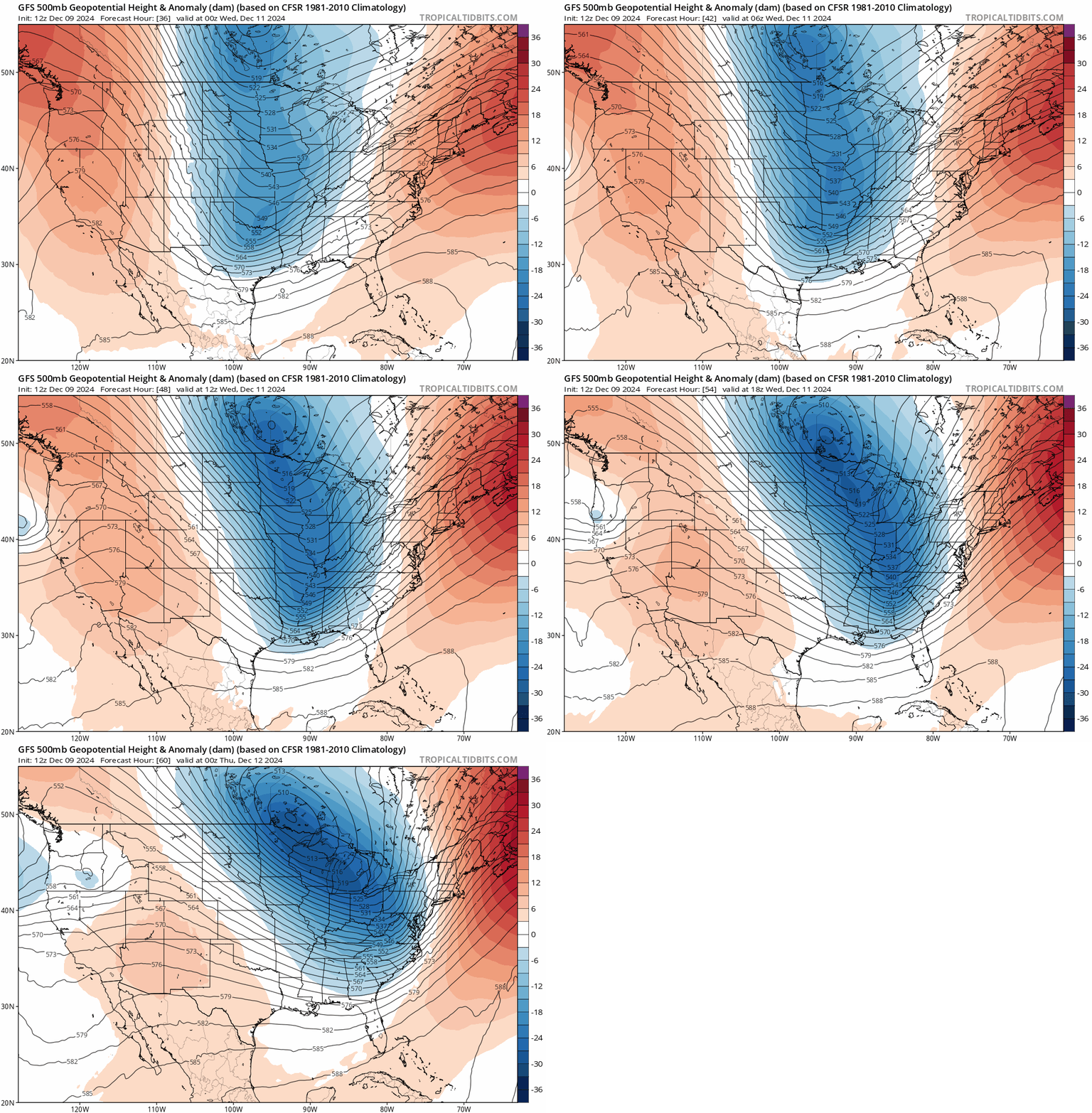
A “negatively-tilted” trough will enhance upward motion in the Mid-Atlantic region on Wednesday afternoon leading to heavy rainfall and possibly powerful wind gusts and a few thunderstorms. Map courtesy NOAA, tropicaltidbits.com
Overview
There has been some rainfall today in the DC-to-Philly-to-NYC corridor which is certainly quite welcome; however, overall amounts will end up being on the low side. Another rain event will follow by mid-week in an active weather pattern and this one is likely to feature significant rainfall that can exceed 2 inches all along the I-95 corridor with a few thunderstorms likely to mix into the picture. In addition to the rain, the winds might become very strong both ahead of the advancing cold front from a southerly direction and also on its backside from a northwesterly direction. In fact, wind gusts to extreme levels of 80+ mph are on the table late Wednesday/Wednesday night near and along the strong cold front along the coastal sections from eastern North Carolina to eastern New England. The combination of a strong surface cold front, plenty of available moisture, and a deep upper-level trough that becomes “negatively-tilted” will lead to this heavy rain event from late Tuesday night through Wednesday evening. A cold blast will follow the passage of the cold front for Thursday and Friday with temperatures on both days well below-normal for this time of year.
Today’s rainfall in the Mid-Atlantic region is welcome news, but it will end up on the low side in terms of total amounts. The mid-week event, however, is likely to bring substantial rainfall to the I-95 corridor region from DC-to-Philly-to-NYC with 2+ inches on the table. Map courtesy NOAA, tropicaltidbits.com
Details
Rain has fallen today across the Mid-Atlantic region which is certainly welcome news in a parched part of the country; however, the quick movement of the system will limit any chances for anything too significant. The next event coming at mid-week, however, will be quite a different story.
Heavy rain is in the offing for the DC-to-Philly-to-NYC corridor from late Tuesday night through Wednesday evening and it could exceed 2 inches in most spots. Temperatures will drop sharply later Wednesday night on the heels of a strong cold frontal passage and it’ll be much colder-than-normal in the Mid-Atlantic region on Thursday and Friday. Map courtesy NOAA, tropicaltidbits.com
An upper-level trough of low pressure will drop into south-central Canada by tomorrow night with a trough axis extending from the center of the low to the south-central US. By late Wednesday, this upper-level trough will have deepened considerably, and its trough axis will take on a “negative-tilt” which suggests it’ll become oriented in a NW-to-SE direction from the center of the low to the eastern seaboard. In this orientation, upward motion will become strongly enhanced across the Mid-Atlantic region by Wednesday afternoon increasing the chance for heavy rainfall. In addition, thunderstorms might form in the increasingly unstable atmosphere and winds can become quite gusty from a southerly direction out ahead of an incoming strong cold front. The rain can exceed 2 inches in the DC-to-Philly-to-NYC corridor in the period from late Tuesday night to Wednesday night which would certainly be beneficial to the overall dry soil conditions across the region.
Powerful winds are possible during the mid-week weather event both on the front side of an advancing strong cold front on Wednesday (from a southerly direction) and on the back side during Wednesday night from a northwesterly direction. In fact, some signs point to wind gusts at extreme levels across eastern New England during this strong cold frontal passage late Wednesday/Wednesday night…on the order of 80+ mph. Map courtesy NOAA, tropicaltidbits.com
Once the cold front slides through on Wednesday evening, temperatures will drop sharply and there is a chance that rain changes to snow for a brief time in some of the N/W suburbs along the Mid-Atlantic’ s I-95 corridor. Winds will remain strong on the back side of the front during Wednesday night - shifting to a northwesterly direction - and they will bring another impressively cold air mass into the Mid-Atlantic region. Farther north, there are signs that wind gusts can reach extreme levels of 80+ mph late Wednesday/Wednesday night across portions of eastern New England. Temperatures may climb to 60 degrees in the DC-to-Philly-to-NYC corridor out ahead of the cold front on Wednesday afternoon , but then are likely hold in the low-to-middle 30’s for afternoon highs on Thursday and Friday...well below-normal for this time of year.
Meteorologist Paul Dorian
Arcfield
arcfieldweather.com
Follow us on Facebook, Twitter, YouTube
Video discussion:


