Contact Us

Use the form on the right to contact us.

You can edit the text in this area, and change where the contact form on the right submits to, by entering edit mode using the modes on the bottom right. 


123 Street Avenue, City Town, 99999

(123) 555-6789

email@address.com


You can set your address, phone number, email and site description in the settings tab.
Link to read me page with more information.

backlit-stratus-clouds-2013-04-05.jpg

Blog

Weather forecasting and analysis, space and historic events, climate information

Filtering by Category: Historic Events

1:00 PM | *Deadly Hurricane Audrey slammed into southwest Louisiana 65 years ago as the strongest June hurricane to ever make landfall in the US*

Paul Dorian

Nowadays, when the people of New Orleans think of devastating hurricanes they think of Katrina, but before 2005, the most notorious storm name in Louisiana was Audrey. Sixty-five years ago today, Hurricane Audrey slammed into the southwest coast of Louisiana and became the earliest major hurricane (category 3) to make landfall in the US. Hurricane Audrey killed hundreds of people – estimated to be somewhere between 400 and 500 - including many of whom to this day remain unidentified and tragically, about one-third of those were children. The high number of deaths - in an era without satellite imagery - were attributed to the storm moving ashore earlier and stronger than predicted while most people were sleeping.

Read More

7:15 AM | *50 years ago this week one of the worst natural disasters Pennsylvania ever faced...Tropical Storm Agnes...DC, Virginia hit hard as well*

Paul Dorian

Track of Agnes from June 14th – June 23rd, 1972 (white circles indicate category 1 hurricane status); courtesy Wikipedia

Overview

The official Atlantic Basin tropical season was barely underway in June of 1972 when a polar front interacted with an upper-level trough of low pressure over the Yucatan Peninsula.  Within a few days, a tropical depression formed and the system moved slowly eastward and emerged in the western Caribbean Sea by the middle of the month.  The depression began to intensify over the warm waters of the Caribbean Sea and soon became Tropical Storm Agnes – the first named storm of the 1972 tropical season.  Ultimately, Agnes would reach hurricane status, grow to a diameter of about 1000 miles, and become the costliest hurricane at the time to hit the US and the Commonwealth of Pennsylvania was the prime focus of its wrath.

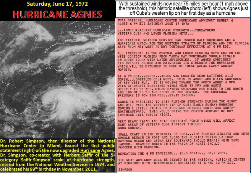
Satellite image of Agnes on the first day it reached hurricane status just off the western tip of Cuba. Courtesy NOAA

General Discussion

Tropical Storm Agnes intensified over the Caribbean Sea in the middle of June 1972 and began curving northward passing just to the west of Cuba on June 17th.  By the next day, Agnes reached hurricane status and then made landfall near Panama City, Florida on June 19th as a category 1 (weak) hurricane.  In typical fashion, the tropical system weakened once it moved over land and dropped back to “depression” status as it pushed northeastward into Georgia.

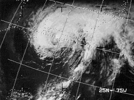
Close-up of Agnes approaching Florida as a category 1 hurricane in June 1972; courtesy NOAA

However, in this particular case, the tropical system then began to regain strength as it pushed through South Carolina and into eastern North Carolina.  In fact, while over eastern North Carolina, Agnes regained tropical storm status as it was about to head out over the waters of the western Atlantic Ocean before re-curving northwestward and making landfall near New York City as a strong tropical storm.  After this, Agnes ran into an atmospheric road block (i.e., upper-level blocking pattern) and this forced it to slow down and loop around into northern Pennsylvania where it eventually gradually dissipated.  The slow movement of Agnes allowed for some incredible rainfall amounts to pile up in the Mid-Atlantic region; especially, in the Commonwealth of Pennsylvania. 

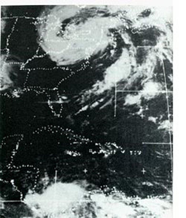
Satellite image of the remnants of Agnes once over the Northeast US; courtesy NOAA

Pennsylvania’s worst nightmare

The weeks before Agnes approached Pennsylvania in June 1972 were quite wet with numerous heavy rain events.  As a result, a disaster was almost unavoidable with the onset of slow-moving Agnes as grounds were already saturated throughout much of the state. As Agnes slowed down to a grinding halt right over northern Pennsylvania, the rainfall amounts piled up across the state and there was intense flooding – more so than in any other state.  In many cases, the rivers rose to levels not ever seen before. The highest rainfall amount of 19 inches was measured over western Schuylkill County and much of the state ended up with at least 7 inches of rain making Agnes the wettest tropical cyclone ever for the state of Pennsylvania (the city of Philadelphia got off easy with only a few inches). 

On June 22, the murky waters of the Susquehanna River reached eight feet above normal. Fourteen hundred National Guardsmen were ordered to the area where they worked to secure low-lying areas by erecting walls of shale, sandbags, and rock. By Friday, June 23, the river swelled to 38.5 feet; the dike had long since buckled and left surrounding towns truly vulnerable. On June 23, 1972, Harrisburg’s Patriot-News was canceled for the first time since it began in 1852. By Saturday evening on June 24th, the water levels had reached their peak and Agnes pummeled Wilkes-Barre and the Wyoming Valley with 14 trillion gallons of water; submerging homes and destroying communities. 

Floodwaters from Agnes surround the Governor’s mansion in Harrisburg, PA

Elsewhere, the Brandywine Creek crested at 16.5 feet in Chadds Ford (Delaware County) sending flooding waters into that city.  In Reading, the Schuylkill River reached a record flood level of 31.5 feet and hundreds of people were evacuated. In the end, more than 100,000 people were forced to leave their homes across the state due to flooding including many in the capital city of Harrisburg where some buildings were under 13 feet of water. Gov. Milton Shapp and first lady Muriel Shapp were rescued by boat from the flooded governor's mansion. By the time the storm finally ended, there were 128 deaths directly attributed to Agnes and 50 of those occurred in Pennsylvania – more than twice that of any other state – and there were $2.3 billion in losses across the Keystone State.

Rainfall amounts from Agnes reached a peak in Pennsylvania with 19 inches recorded in western Schuylkill County

Impact on the DC metro region

Rainfall amounts were staggering across Pennsylvania and also in much of the DC metro region. Chantilly, Virginia, for example, recorded 16 inches from Agnes and 13.65" officially fell at Dulles Airport.  Wind gusts peaked at around 50 mph at Dulles and National Airports (8.16” inches of rainfall recorded at DCA).  The most tragic aspect of this event in the Washington D.C. area was the loss of sixteen people who were swept to their deaths in the swirling floodwaters. Most of these drownings involved motorists that were trapped in automobiles (credit Washington Post's Capital Weather Gang).

Final thoughts

Hurricane Agnes finally exited Pennsylvania on June 25, 1972 with its sights set on western New York. By most accounts, the scope of the devastation puts Hurricane Agnes at the top of Pennsylvania’s worst natural disasters, even though it did not cause the most deaths. The two deadliest, both of which occurred on May 31, were the Johnstown Flood of 1889 (2200+ fatalities) and the Great Pennsylvania Tornado of 1985 (65 fatalities) [credit Washington Post/Capital Weather Gang].  

Agnes left quite a legacy among those who suffered her wrath; consequently, the name was retired by NOAA and barred from future use.  In fact, Hurricane Agnes was the first category 1 hurricane in the Atlantic Basin to have its name retired and is today one of only five such storms with that distinction.

Meteorologist Paul Dorian
Arcfield
arcfieldweather.com

Follow us on Facebook, Twitter, YouTube


7:15 AM | *California-to-Texas heat to intensify and expand eastward next week to Southeast US...revisiting the brutally hot summer of 1980...hard-pressed to match that one*

Paul Dorian

Highs temperatures on Friday are likely to reach 100 degrees in Dallas, Texas and this could begin an impressive string of days at or above the century mark in that particular location. High pressure ridging has been quite strong recently in the region from California-to-Texas and it will intensify over the next few days and then build eastward next week all the way to the Southeast US coastline. It is not unprecedented to see this kind of June heat in Texas or other parts of the southern states and Dallas will have a tough time matching the sustained and extreme heat of the summer of 1980.

Read More

7:15 AM | *Ike said simply "we had better meteorologists"...the most important weather forecast of all-time: D-Day, June 6, 1944*

Paul Dorian

With thousands of lives on the line, there is no doubt that the weather forecast made for the D-Day invasion in Normandy, France during World War II was the most important of all-time and one of the most difficult as well given the lack of sophisticated forecasting tools that we enjoy in today’s world. The first satellite image was still nearly sixteen years away (TIROS on April 1, 1960) and reliable computer forecast models were still decades away. Today, June 6th, marks the 78th anniversary of the D-Day invasion and the weather forecast for that historic event makes for quite an interesting story in what turned out to be a pivotal moment in world history. Years of detailed planning went into the D-Day invasion on June 6, 1944, but success hinged on one element that no military commander could control — the weather. Defying his colleagues, Captain James Martin Stagg advised General Dwight “Ike” Eisenhower to postpone the invasion of Normandy by one day from June 5th to June 6th because of uncertain weather conditions in a weather forecast that changed the course of World War II and altered world history.

Read More

7:15 AM | *It was during the height of the Cold War and a solar storm nearly sparked a nuclear confrontation*

Paul Dorian

It was during the height of the Cold War and a powerful solar storm could have led to a disastrous military conflict between the US and Soviet Union if not for the early efforts of the US Air Force to monitor solar activity. On May 23rd, 1967, a solar storm took place that was so powerful, it jammed radar and radio communications in polar regions and the US Air Force actually began to prepare aircraft for war thinking the nation’s surveillance radars were being jammed by the Soviet Union. Fortunately, space weather forecasters in the military suspected there might be another cause and they relayed information about the possibility that a solar storm could have been the reason for the disrupted radar and radio communications. As it turned out, this information was enough to keep the planes on the ground and the US avoided a potential nuclear weapon exchange with the Soviet Union.

Read More

7:15 AM | *The greatest geomagnetic storm of the 20th Century…May 13-15, 1921…New York City/New York State were especially hard hit*

Paul Dorian

The most intense geomagnetic storm of the 20th Century took place during solar cycle 15 in a 3-day period from May 13-15 in 1921. The storm occurred before the widespread electrical dependence of infrastructure that we have in today’s world, but the impact from an extraordinarily powerful coronal mass ejection was still quite extensive. The storm’s electrical current sparked a number of fires around the world including one near the Grand Central Terminal in New York City. In addition, auroras appeared throughout the eastern US creating brightly lit nighttime skies and telegraph service virtually stopped in its tracks due to blown fuses and damaged equipment. Research in recent years has suggested that this super solar storm of May 1921 was equally as intense as the granddaddy of all super storms in recorded history – the “Carrington Event of 1859”.

Read More

7:15 AM | *This Friday marks the 85th anniversary of a major tragedy that took place in Lakehurst, New Jersey...the role of the weather in the Hindenburg disaster of May 6th, 1937*

Paul Dorian

Weather played an important role in the 1912 disaster of the sinking of the Titanic and it likely played a direct role in another disaster that took place 25 years later – at least that is the prevailing belief. On May 6th, 1937, while the German passenger airship LZ 129 Hindenburg was attempting to land at the Lakehurst Naval Air Station in New Jersey, a flame appeared on the outer cover of the rear of the ship. Within 34 seconds, the entire airship was consumed by fire and the golden age of airship travel was over.

Read More

7:15 AM | *The role of weather in the sinking of the Titanic on April 15th, 1912...110 years ago today*

Paul Dorian

This Friday marks the 110th anniversary of the sinking of the RMS Titanic (April 15, 1912) and I thought I’d revisit the overall weather pattern that played a key role in the tragedy. By studying weather maps and written records from that time period, some definitive conclusions can be drawn about the weather during the trip across the Atlantic, and there are also some interesting relatively new theories involving atmospheric conditions and their possible effects.

Read More

7:15 AM | *Only about two years away from the next "Great American" total solar eclipse...get ready for April 8th, 2024*

Paul Dorian

It was almost five years ago when America went crazy for the first coast-to-coast total solar eclipse on US soil since 1918 and it provided a great opportunity for scientists. What was referred to as “The Great American Solar Eclipse” took place on August 21st, 2017 when the moon passed between the sun and earth. The result was a 67-mile wide shadow that crossed the country all the way from Oregon-to-South Carolina. Total solar eclipses occur somewhere on Earth every year or so, but generally cast their shadows over oceans or remote land masses. If you missed the 2017 total solar eclipse or it turned out to be cloudy in your particular area then there will be another opportunity in just two years during April of 2024.

Read More

7:15 AM | *The Great Blizzard of March 18-21, 1958…one of the worst snowstorms ever in eastern Pennsylvania*

Paul Dorian

March is known to feature some crazy and surprising weather and the 1958 blizzard that occurred in the Mid-Atlantic region between March 18th and 23rd was indeed rather unexpected. In general, forecasts on the morning of March 18th had no mention of snow. This was in an era before computer forecast models were being utilized by weather forecasters on a daily basis and it was even before satellite imagery existed which could aid in the forecast. By afternoon on that particular day, the light rain had changed into huge, wet snowflakes and - for the next few days - history was being made.

Read More