Sat. PM - ****Accumulating snow in the DC-to-Philly-to-NYC corridor on Sunday at the front end of an Arctic invasion…several inches on the table…brutal cold to follow with near zero possible****
Paul Dorian
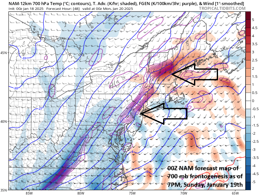
A strong area of “frontogenesis” will develop later Sunday in the area of southeastern PA and points to the north and east of there and this could result in some heavy snow bands and perhaps even some “thunder snow” during this upcoming event. Map courtesy NOAA, tropicaltidbits.com
Overview
The next several days will feature the worst that winter has to offer across the nation with widespread brutal cold and multiple snow and ice threats. An Arctic invasion with a Siberian connection will get underway by Saturday as bitter cold air from Canada plunges southward through the central states. By Sunday, the Arctic air mass will spread eastward towards the Atlantic seaboard and by the time we get to Monday, Inauguration Day, most of the country will be in a deep freeze including the DC metro where outdoor activities are planned for the swearing-in ceremonies. In fact, the first couple of days of next week could be among the coldest seen across the nation in a long time as there will be bitter cold conditions extending virtually from coast-to-coast.
This cold weather pattern will come with as many as three threats of snow and ice during the next week to ten days. On Sunday, low pressure will form along the incoming Arctic frontal boundary zone and likely produce several inches of snow across the Mid-Atlantic region and Northeast US - and this includes in the big cities along the I-95 corridor from DC-to-Boston. Another storm is destined to form over the Gulf region by mid-week and its focus could be on the southern states with significant snow and ice a possibility from Texas to the Carolinas…the snow shield can potentially work its way into the Mid-Atlantic region. Yet another system can again develop way down in the southern states by the end of next week or during the subsequent weekend.
Overnight temperatures are likely to drop into the range of 0 to 5 above (degrees F) all along the I-95 corridor during the first half of next week. Map courtesy ECMWF, Weather Bell Analytics
The Arctic blast (with a Siberian connection)
The colder-than-normal weather pattern that began earlier this month across the central and eastern US not only looks like it will be extend through the third week of January, but it is going to go to more extreme levels. The outbreak of Arctic air will get underway by early Saturday over the north-central states and the bitter cold air mass will plunge southward all the way into the heart of Texas by late Saturday and then it spreads eastward on Sunday.
Temperatures will fall to well below-normal levels across much of the nation for the first half of next week which is quite impressive indeed considering this is right around the time of year with the lowest “normal” temperatures. In fact, a huge chunk of the Northern US will see their temperatures drop to well below zero by early next week. The first couple of days of next week could turn out to be the coldest in a long time across the nation with the brutal cold extending virtually from coast-to-coast. The upper-level pattern across North America has evolved into one that is producing “cross-polar” flow allowing for Siberian air to cross the North Pole and drop into Canada and the US. Siberia is land mass known for its extremely cold air masses this time of year as, for one reason, it typically features a very deep snowpack.
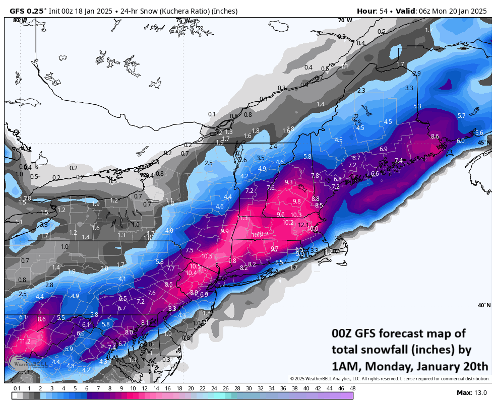
Snow will break out on Sunday in the DC-to-Philly-to-NYC corridor as a wave of low pressure forms along an incoming Arctic frontal boundary zone with several inches on the table in the big city metro regions. Map courtesy NOAA, tropicaltidbits.com
Sunday snowstorm in the Mid-Atlantic/Northeast US
On Sunday, the Arctic front at the leading edge of the Arctic air mass will slide into the eastern states and its progression will likely slow down across the southeastern states. Energy will rotate through an upper-level trough on Sunday, and this will open the door for an Arctic wave of low pressure to form along the front’s temperature gradient zone which is typically a favorable area for convergence in the atmosphere. That low pressure system will then push northeastward into an increasingly colder air mass, and it can produce snow or perhaps rain that quickly changes to snow in the DC-to-Philly-to-NYC corridor from Sunday into Sunday night with several inches on the table as follows:
DC: 3-6 inches with isolated higher amounts (mid-morning starting time)
Philly: 4-8 inches with isolated higher amounts (mid-day starting time)
(The snow will make for quite an interesting Eagles-Rams game at 3pm on Sunday in South Philadelphia).
NYC: 4-8 inches with isolated higher amounts (mid-afternoon starting time)
Note - the higher amounts in these snowfall ranges will be on the northwestern side of the metro regions and the lower amounts will be on the southeastern side
One other note…in the area of maximum “frontogenesis” from southeastern PA to points north and east of there, “thunder snow” is indeed a possibility
Inauguration Day (Monday) weather…a frigid DC with a fresh snow cover
By Monday, January 20th, the bitter cold air will be firmly established across much of the nation, and this includes in the DC metro region where outdoor activities have been cancelled for the Inauguration Day ceremonies. Temperatures are likely to be near 20 degrees at noontime on Monday in the DC metro area - the coldest Inauguration Day since 1985 (more info below) - and there will be a biting wind to make it feel even colder than the actual air temperatures. In addition, there is likely to be a fresh snow cover in the DC metro region on Monday following what I expect to be accumulating snow to precede on Sunday. Temperatures on Monday night (and also on Tuesday night) should easily drop into single digits along the DC-to-Philly-to-NYC corridor and they could bottom out near zero degrees with the added benefit of some fresh snow cover (usually knocks off a few degrees).
It was so cold on January 20th, 1985 that all outdoor activities for Ronald Reagan’s second swearing-in ceremony were cancelled. Temperatures were in single digits at the noon swearing-in time in Washington, D.C. on January 20th during what was an extremely cold Arctic air outbreak. Map courtesy NOAA
The last Inauguration Day that was impacted considerably by the weather took place in January of 1985 for Ronald Reagan’s second term. It was so cold on that day in Washington, D.C. with an Arctic outbreak into the eastern states that all outdoor activities were cancelled. The outside temperature at noon on January 20th was only 7°F and wind chills during the afternoon were in the -10 to -20°F range. That particular cold wave in January of 1985 followed a major stratospheric warming event that got underway during December of 1984.
The last time snow played a big role in an Inauguration was in January of 1961 when eight inches fell on the eve of JFK’s swearing-in ceremony. The snowfall caused the most crippling traffic jam the District had ever seen up to that point with hundreds of cars abandoned on the local roadways. By sunrise on the 20th, the snow had ended, and the skies were clearing, but the day remained bitterly cold. An army of men worked all night to clear Pennsylvania Avenue and despite the cold, a large crowd turned out for the swearing-in ceremony and inaugural parade. At noon, the temperature was only 22°F and the wind was blowing from the northwest at 19 mph making it feel like 7°F above zero. (For some excellent information on “Inauguration Day weather” visit this NWS site).
There is a good chance that a storm system forms over the Gulf coastal region by the middle of the week and this can bring significant snow and ice to the southern states from Texas to the Carolinas. There is even the “non-zero” chance of some snow and/or ice across the northern part of Florida. Map courtesy ECMWF, weathermodels.com
Mid-week and late week storm threats
It’ll remain brutally cold on Tuesday and Wednesday across much of the nation (below-freezing temperatures all the way down to the Gulf coast) and a new wave of energy will rotate through the base of a large-scale upper-level trough and head towards the south-central states. This support in the upper part of the atmosphere could help to spawn surface low pressure over the Gulf of Mexico by the middle of next week and, if so, it would have plenty of well-established cold air to work with. Indeed, this system has the potential of generating significant snow and ice all the way from Texas to the Carolinas and this threat zone can even include places as far south as northern Florida. Such unusual southern cities as Houston (TX), New Orleans (LA), Tallahassee (FL), and Myrtle Beach (SC) can be impacted with wintry (i.e., frozen) precipitation by this mid-week storm system.
The storm system will slide eastward across the Gulf states and could take a turn to the northeast as it approaches the eastern seaboard…potentially bringing more snow to the Mid-Atlantic region. Looking even farther down the road, there may be yet another wave of energy headed towards the south-central US by late next week and this too can help to spin-up a storm system near the Gulf coast by week’s end or the early part of the subsequent weekend
Meteorologist Paul Dorian
Arcfield
arcfieldweather.com
Follow us on Facebook, Twitter, YouTube
Video discussion:


