2:00 PM | ***”Backend” snow to deal with in parts of the Mid-Atlantic region from the current winter storm...monitoring a late week/early weekend storm threat for the Deep South and eastern states***
Paul Dorian
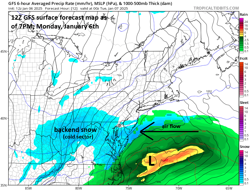
Moist air flowing along the so-called “cold conveyor belt” around a mature mid-latitude cyclone can be “lifted” sufficiently to result in accumulating snowfall across the system’s northwest (cold) sector. This will be the case late today and early tonight in the region from DC-to-the Delmarva-to-southern NJ and potentially as far north as southern PA. Map (7PM, Monday) courtesy NOAA, tropicaltidbits.com
Overview
Low pressure that has produced accumulating snow today in much of the Mid-Atlantic region will shift to the western Atlantic Ocean during the next hour or so; however, it is not necessarily through with our area just yet. Snow is developing in the northwest sector of this eastward-moving storm system and this “backend” snow will impact the region from DC-to-the-Delmarva-to-southern NJ late today and early tonight and likely up across southern PA as well. In fact, there can be additional snow accumulations in some areas of up to a couple of inches before the precipitation shield finally fully departs the Mid-Atlantic region. On the backside of the storm late tonight and Tuesday, stiff NW winds will develop and can gust past 40 mph or so making it feel even colder than the actual air temperatures.
Looking ahead, this cold and active weather pattern threatens to produce another storm system late this week and weekend. This time, the location of the storm development will be way down south likely over the northwestern Gulf of Mexico by week’s end. As such, there can be an impact in the Deep South and this can even include significant accumulating snow and ice across places like Texas and Arkansas. After that, the low pressure system likely heads towards the eastern seaboard and the timing of its intensification along the coast will be critical in determining how much impact there can be in the Mid-Atlantic region and Northeast US. A quick intensification along the Mid-Atlantic coastline could mean significant accumulating snow in the DC-to-Philly-to-NYC corridor or the system may “wait” until it pushes farther to the north and east to intensify which would likely limit any big impact to eastern New England.
Moist air flowing along the so-called “cold conveyor belt” around a mature mid-latitude cyclone can be “lifted” sufficiently to result in accumulating snowfall across the system’s northwest (cold) sector. Indeed, this looks like this will take later today and early tonight in the region from DC-to-the Delmarva-to-southern NJ, and likely as far north as southern PA. Map (1AM, Tuesday) courtesy NOAA, tropicaltidbits.com
Backend snow late today/early tonight in portions of the Mid-Atlantic
Precipitation has slackened off in most of the Mid-Atlantic region from today’s storm system, but there are some radar echoes developing in the departing low pressure system’s northwest (cold) sector. With the surface low pressure now shifting to the western Atlantic, cool and moist ocean air - just to the north of a warm frontal system – is being transported westward and “lifted” as it moves into the cold air sector to the north and west of the low…traveling along the so-called “cold conveyor belt”. This process helps to create the typical “comma-shaped” appearance to the cloud pattern in fully-matured mid-latitude winter storms (and sometimes to the radar echoes as well). This “cold conveyor belt” snow is also referred as “wrap-around” or “backlash” snow and it can produce additional accumulations on the backside of the storm. This type of backend snow is likely to push into the region from DC-to-the Delmarva-to-southern New Jersey late today and early tonight and there is a good chance it makes it all the way into southern PA as well. In fact, some areas can receive an additional couple of inches of snow from this backend snowfall; especially, to the south of the PA/MD border. Once the storm’s precipitation shield finally fully departs the Mid-Atlantic region later tonight, the winds will become the main factor, and they can gust past 40 mph on Tuesday from a northwesterly direction.
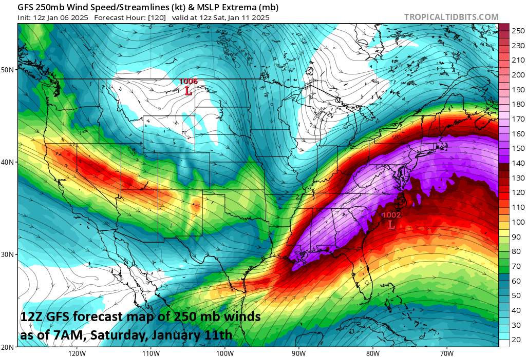
An important factor with respect to the possibility of a late week/weekend storm system will be a vigorous jet streak in the upper part of the atmosphere that is shown on this forecast map on Saturday morning just to the west of the east coast (peak wind speeds at 250 millibar are shown in purple). Map courtesy NOAA, tropicaltidbits.com
Late week/weekend storm threat for the Deep South and east coast
This cold weather pattern for the central and eastern US is likely to continue well into the month of January and perhaps even into February and an active southern branch of the jet stream will assure that it remains quite active as well. Indeed, a strong jet streak later this week can set the stage for a Gulf of Mexico storm system which can ultimately take a trek up along the eastern seaboard.
The early part of the upcoming weekend will feature a strong upper-level low pressure system situated over the Tennessee Valley aiding in the development of low pressure near the eastern seaboard. Map courtesy NOAA, tropicaltidbits.com
There are still several days to go and the timing of potential “phasing” between a couple of waves of energy is far from certain, but the potential is there for an impactful late week and weekend storm system. A southern stream shortwave ejecting from the Baja California region will try to phase with northern stream energy and the timing of this will be critical as far as the Mid-Atlantic region and Northeast US are concerned.
The threat exists for significant snow and ice in Texas late this week as low pressure forms over the northwestern part of the Gulf of Mexico with cold air penetrated deep into the southern states. Map courtesy NOAA, tropicaltidbits.com
The first impacted region from this next storm could be the states of Texas and Arkansas where there is the chance for significant accumulating snow and ice by week’s end. After that, the low pressure system likely heads towards the eastern seaboard and the timing of its intensification along the coast will be critical in determining how much impact there can be in the Mid-Atlantic region and Northeast US. A quick intensification along the Mid-Atlantic coastline could mean significant accumulating snow in the DC-to-Philly-to-NYC corridor or this system may “wait” until it pushes farther to the north and east to intensify which would likely limit any big impact to eastern New England…stay tuned.
Meteorologist Paul Dorian
Arcfield
arcfieldweather.com
Follow us on Facebook, Twitter, YouTube
Video discussion:


